Area 3 Minnesota River Bank Stabilization Project,
Eden Prairie, Minnesota
-
Project Information
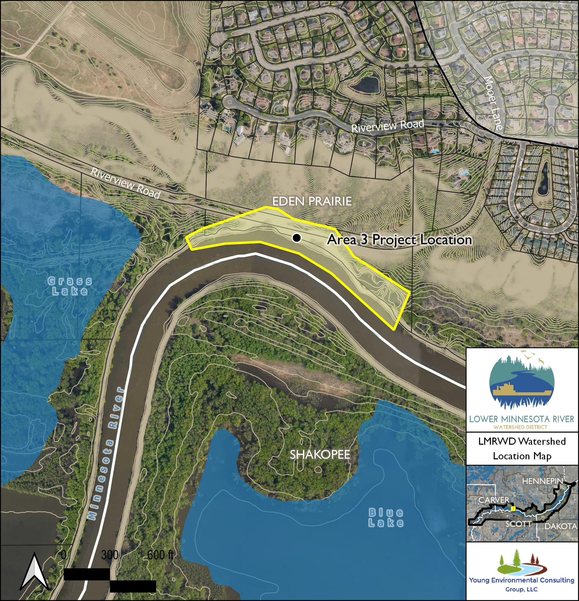
Area 3 is located along the north bank of the Minnesota River, south of the Riverview Road cul-de-sac and intersection with Mooer Lane in Eden Prairie, Minnesota (Attachment 1). In 2008, the City of Eden Prairie (City) and the Lower Minnesota River Watershed District (LMRWD) commissioned a study to determine the causes of the instability and identify alternatives for permanent stabilization of the slopes (Attachment 2). The City and LMRWD conducted a second study in 2010 to collect additional information to evaluate the proposed and potential new ideas or designs (Attachment 3). The probable cause of the slope instability and erosion were determined to be natural processes from groundwater seepage and the river meander that have been accelerated by changes in climate and hydrology. The consensus was that, if left unchecked, the bluff erosion would likely continue because of the river meander. The 2010 study also evaluated the slope stability of the bluff as there are residents and municipal structure at the top of the bluff. It was determined that there was an acceptable factor of safety.
Three alternatives were proposed because of the 2010 study. The final recommended option, Alternative 3, was construction of rock vanes within the river to deflect flows from the eroded banks, grading and shaping of the eroded slope, and live stake plantings.
Concurrent with the development of the 2010 study, and because of the perceived slope stability concerns, the LMRWD installed inclinometers to monitor bluff movement in 2010. To date, the inclinometers have not shown any indication of movement of the hillside (Attachment 4).
In 2019, the LMRWD convened a group of professionals involved in the 2010 study, including the LMRWD engineer, to reevaluate the 2010 proposed designs and inclinometer data. Although there has not been documented movement of the slope, the natural erosion processes coupled with historic water levels on the Minnesota River are threatening the City’s stormwater pond at the downstream end of the study reach. Over the course of 2020, additional data have been collected, including a field reconnaissance visit, bathymetric survey, updated hydrology, and installation of a vibrating wire to record water levels in the embankment (Attachments 5 and 6).
-
Request for Proposals
This request for proposal (RFP) is intended to solicit responses from qualified consultants or teams (Consultant) for services related to the stabilization of approximately 1,500 feet of riverbank along the Minnesota River in Eden Prairie, Minnesota (Attachment 1). The selected consultant will enter into a professional services agreement with the LMRWD for the preparation of design and construction documents for the Area 3 Minnesota Riverbank Stabilization Project.
-
RFP Key Dates
|
RFP Release Date |
December 17, 2020 |
|
Mandatory Pre-Proposal Meeting* |
January 6, 2021, at 1 p.m. |
|
Questions Due |
January 8, 2021, at 4 p.m. |
|
Final Addenda Issued |
January 13, 2021 |
|
Proposals Due |
January 22, 2021, at 2 p.m. |
|
Shortlisted Teams Notified |
January 29, 2021 |
|
Tentative Interview Date |
February 4, 2021 |
|
Tentative Contract Award |
February 17, 2020 |
*Interested parties must email Linda Loomis, LMRWD Administrator, at admin@lowermnriverwd.org for an invite to the mandatory pre-proposal meeting.
-
RFP and Attachments
- Addendum No. 1, January 11, 2021
- RFP Area 3 Minnesota Riverbank Stabilization Project
- Attachment 1 - Project Location
- Attachment 2 - October 2008 Study Area 3 Final Report
- Attachment 3 - February 2010 Minnesota River Bank and Bluff Stabilization Report
- Attachment 4 - Inclinometer Readings
- Attachment 5 - 2016 MN River Erosion Monitoring Memo
- Attachment 6 - City Meeting Summary_17Jan2020
- Attachment 7 - Site Visit Summary_07May2020
- Attachment 8 - Project Update_16Oct2020
- Attachment 9 - 2020 Bathymetric Survey
- Attachment 10 - USACE HEC-RAS Mode