Stream ID
Minnesota Department of Natural Resources (MNDNR) stream ID M-055-002-001
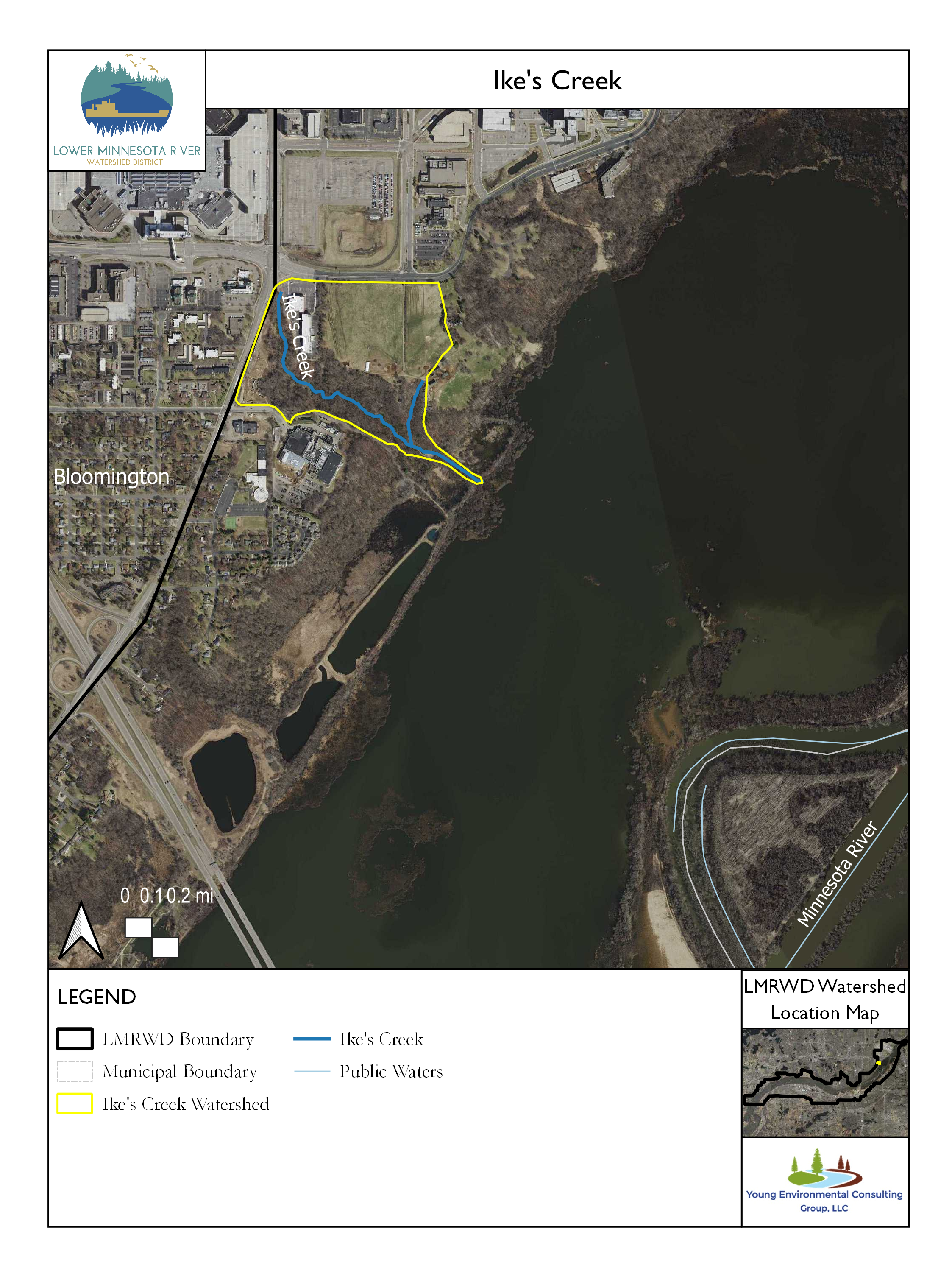
Ike’s Creek, officially unnamed but also known as Hust Creek, is a 0.61-mile (0.99-kilometer) stream in Hennepin County in the City of Bloomington, Minnesota. Much of the creek is part of the Minnesota Valley National Wildlife Refuge. It flows into Long Meadow Lake, which empties into the Minnesota River. It became known as Ike’s Creek because the Isaak Walton League operated trout-rearing ponds in the early 1900s near where the creek flows into Long Meadow Lake and encounters the floodplain of the Minnesota River.
Ike’s Creek originates near the Mall of America and is almost entirely fed by discharge from groundwater springs. Most surface drainage has been routed away from the creek, which may protect the creek from polluted runoff. The sustained flow of cold, clear groundwater suggests the creek may provide a sustainable trout habitat. It was reported that the stream historically had a native trout population, which inexplicably disappeared (Niskanen 2007).
Ike’s Creek is not officially designated as a trout stream. The Lower Minnesota River Watershed District (LMRWD) and local government entities protect the stream. The MNDNR considered Ike’s Creek for a trout stream designation in 2017, but at the request of the city and local stakeholders, it was not designated because it is already protected by existing ordinances and permitting requirements (C. e. Berg 2019). State trout stream designation has restrictions that were considered difficult and unnecessary to protect the creek. It is managed in partnership by the City of Bloomington, the LMRWD, the Metropolitan Council of the Twin Cities, the MNDNR, and the US Fish and Wildlife Service (USFWS).
Land Use
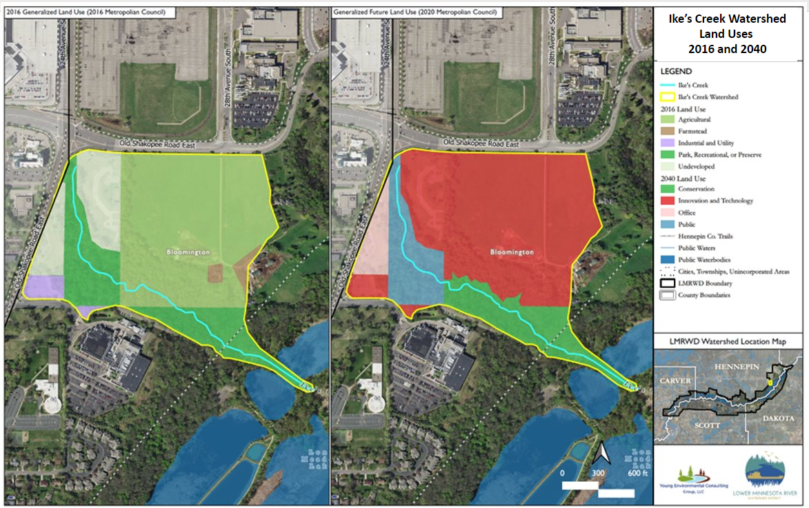
The illustration of land use in the Ike’s Creek watershed shows that 35 acres of the watershed are agricultural, with 24 acres of park, recreational, preserve, and undeveloped land. Only about 2 acres of the 61-acre watershed are considered mixed use, commercial, or industrial. Future land use will generally transition from park, recreational, and preserved to mixed use, commercial, and industrial.
Trout
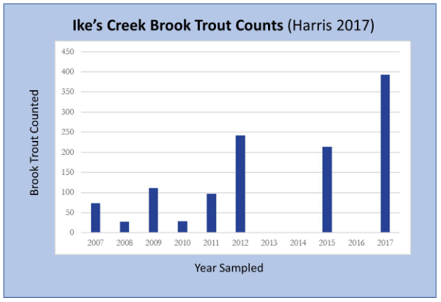
In 2007, brook trout were reintroduced to Ike’s Creek by stocking the creek with 1,450 fingerling Minnesota-native brook trout, of which approximately 200 survived (Nerbonne 2007). The creek has been sampled regularly since the reintroduction with the goal of establishing a population of 500 brook trout per mile. This goal was achieved in this 0.61-mile-long creek for the first time in 2017 (Harris 2017). A summary of the MNDNR fish counts is shown in the adjacent chart.
Monitoring Data
Water Quality
The Metropolitan Council Environmental Services (MCES) collects samples from two sites on Ike’s Creek on behalf of the USFWS, the LMRWD, and other stakeholders. The samples are analyzed for selected major ions and related water quality indicators. The samples are typically collected on the same date at stream miles 0.6 and 0.2 upstream of the mouth from late March through late June 2021 and December 2021 through April 2022. This ongoing sampling is summarized in the adjacent table.
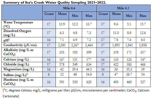
Ike’s Creek is almost entirely supplied by groundwater discharge rather than runoff. This relatively stable supply means the water has a small range in chemical concentrations and water quality indicators. It is expected that the chemistry of the creek water is comparable to the water found in the aquifers that supply water to the creek. However, data specifically characterizing the groundwater chemistry near the creek were not found. Marl deposits were observed at several locations along the creek (Ferrington 2020; Young 2022). Marl is a precipitate formed when groundwater saturated with calcium and magnesium carbonates comes out of solution from the water as the chemistry changes during the transition from groundwater to open-water conditions. After excess calcium and magnesium carbonates are precipitated, the creek water should be nearly saturated with those chemicals, and the high concentrations measured confirm that process.
The water temperature, dissolved oxygen concentration, pH, and other measured values in Ike’s Creek provide a habitat favorable to the reestablished trout population. However, chloride concentrations are unexpectedly high. The mean concentration of 578 milligrams per liter (mg/L) at mile 0.6 and 422 mg/L at mile 0.2 are much higher than the 230 mg/L criteria for the protection of aquatic life (MPCA 2018). The elevated chloride is likely in the groundwater discharging to the creek because groundwater containing elevated chloride from human-caused sources is found throughout the Twin Cities area (J. A. Berg 2021).
It is uncertain whether these concentrations harm the introduced brook trout population. A study of newly hatched rainbow trout exposed to sodium chloride for 25 days showed no effects at concentrations as high as 860 mg/L (Hintz and Relyea 2017). With the high calcium concentrations found in the creek, calcium chloride concentrations may be a concern. Calcium chloride concentrations above 860 mg/L affected trout growth (Hintz and Relyea 2017). Many confounding factors make the applicability of the results from Hintz and Relyea (2017) uncertain for Ike’s Creek. Additional studies and assessments by fisheries’ biologists and biochemists may help to determine whether these elevated chloride concentrations affect trout or invertebrate populations and other organisms that comprise the food web supporting the trout population.
Ike’s Creek is not open to fishing, but people may gain access in some places. The Bass Pond Trail maintained by the Minnesota Valley National Wildlife Refuge accesses the creek near its mouth. Other public trails maintained by the City of Bloomington also provide access.
A more thorough evaluation of the Ike’s Creek habitat and considerations for management are discussed in the report Trout Streams Gaps Analysis and Management Plan (Young 2022).
References
Berg, Christina et. al. 2019. "Geomorphic and Habitat Assessments of Trout Streams in the Lower Minnesota River Watershed District." Lower Minnesota River Watershed District. August. http://lowermnriverwd.org/application/files/4115/7307/3877/LMRWD_Trout_Geo_and_Hab_Asse__Final_Draft_Nov2019.pdf.
Berg, James A. 2021. Groundwater Atlas of Hennepin County: Water Chemistry. County Atlas Series C-45, Part B; Plate 7 of 9, St. Paul, MN: Minnesota Department of Natural Resources. https://files.dnr.state.mn.us/waters/groundwater_section/mapping/cga/c45_hennepin/hennepin_plate7.pdf.
Ferrington, LC, PhD. 2020. "Oral Communication." St. Paul, MN, Sep 29.
Harris, Jason. 2017. Ike's Creek Resurvey Report. Survey, St. Paul, MN: Minnesota Department of Natural Resources.
Hintz, WD, and RA Relyea. 2017. "Impacts of road deicing salts on the early-life growth and development of a stream salmonid: Salt type matters." Environmental Pollution 223:409-415. doi:10.1016/j.envpol.2017.01.040.
MPCA. 2018. TCMA Chloride TMDL - Applicable Water Quality Standards and Numeric Water Quality Targets. May 18. https://stormwater.pca.state.mn.us/index.php/TCMA_Chloride_TMDL_-_Applicable_Water_Quality_Standards_and_Numeric_Water_Quality_Targets.
Nerbonne, Brian. 2007. Unnamed Stream Trib. Number: M-55-002-001 Resurvey. Survey, St. Paul, MN: Minnesota Department of Natural Resources.
Niskanen, Chris. 2007. www.twincities.com. June 16. https://www.twincities.com/2007/06/16/creek-near-mall-of-america-becomes-a-trout-stream-again/.
Young. 2022. Trout Streams Gaps Analysis and Management Plan - Draft Report. Resource Assessment, Chaska, MN: Lower Minnesota River Watershed District. http://www.lowermnriverwd.org/application/files/5916/5245/1920/LMRWD_Trout_Streams_Gaps_Analysis_and_Management_Plan_20220512r.pdf.
This data last updated August 2022.