Lake ID
Minnesota Department of Natural Resources (MNDNR) site ID 27000100. This link provides available information on lake location, morphometry, and fisheries.
Minnesota Pollution Control Agency site ID 27-0001-00. This link provides available information on lake chemistry.
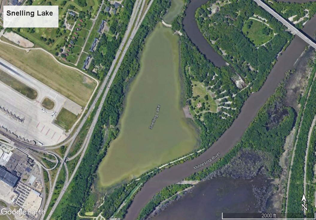
Snelling Lake is part of Fort Snelling State Park in the city of St. Paul, Minnesota and is downhill from the Minneapolis-St. Paul International Airport. Alternate names for this lake include G I Lake, Government Lake and Soldiers Lake (HookandBullet.com, 2021). It is classified as a Class 2B water for warm-water fish and aquatic life (MPCA, 2021).
Snelling Lake has a natural (unpaved) boat-launch ramp at the south end and a fishing pier at the north end. Boat motors are prohibited. A swimming beach is maintained along the eastern shore. It is aerated in the winter to oxygenate the water and prevent fish kills under ice.
Snelling Lake is in the floodplain of the Minnesota River. Floodplain lakes, with their complex hydrology and ecosystems, are subject to periodic flooding which introduce water, sediment, and aquatic life.
Water quality monitoring activities for floodplain lakes have been either eliminated or reduced because of the regular intrusion of water from the Minnesota River. Sediment and paleolimnological assessments have been periodically completed to understand the quantity and quality of sediment deposition in some of the floodplain lakes from the Minnesota River. Water chemistry data were not found for Snelling Lake.
Fisheries surveys have been conducted by the MNDNR. The most recent survey of Snelling Lake was conducted on June 6, 2017. It showed the bullheads and sunfish were the most abundant, but northern pike numbers were unexpectedly high and the longest was 33 inches (nearly 1 meter) (MNDNR, 2021). The lake was stocked with 20 1-pound largemouth bass in 2018 (MNDNR, 2021).
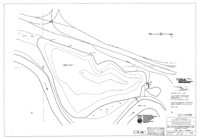
The lake is 8 feet (2.4 meters) deep and has an area of 103 acres (42 hectares). The adjacent graphic shows the depth (bathymetry) of Snelling Lake provided by the MNDNR (MNDNR, 2021).
Monitoring Data
Transparency
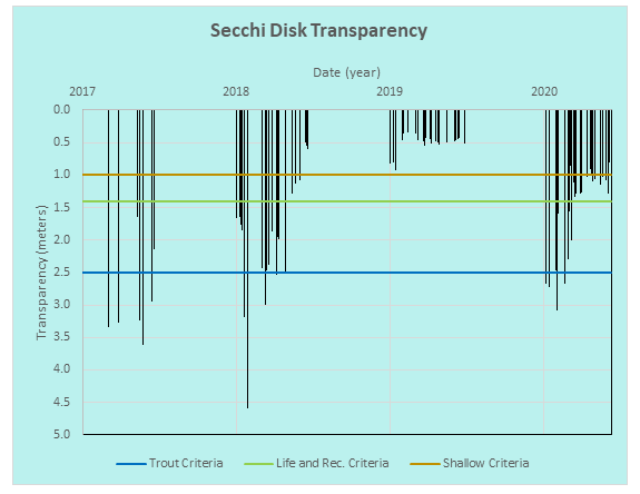
The transparency, a measure of water clarity, of Snelling Lake is variable, ranging from 0.34 meters (1 foot) to 4.6 meters (15 feet). Some of the readings exceed the 2.5-meter criteria for Class 2A trout lakes in Minnesota (Statutes, 2021) but during 2019 all the readings were less than the criteria for shallow lakes.
References
HookandBullet.com. (2021, Oct 16). Snelling Lake Fishing. Retrieved from Hook and Bullet: https://www.hookandbullet.com/fishing-snelling-lake-mendota-heights-mn/
MNDNR. (2021, Sep 14). Available maps. Retrieved from Lakefinder showmaps: https://www.dnr.state.mn.us/lakefind/showmap.html?mapid=B0299&downum=27000100
MNDNR. (2021, Sep 14). Lakefinder Showstocking. Retrieved from Snelling (27000100): https://www.dnr.state.mn.us/lakefind/showstocking.html?downum=27000100&context=desktop
MNDNR. (2021, Sep 14). Snelling (27000100). Retrieved from Lakefinder Showreport: https://www.dnr.state.mn.us/lakefind/showreport.html?downum=27000100
MPCA. (2021, Oct 16). Snelling: St. Paul (Lake). Retrieved from Lake and streams water quality dashboard: https://webapp.pca.state.mn.us/surface-water/impairment/27-0001-00
Statutes, M. (2021, August 10). Minnesota Administrative Rules 7050.0222. Retrieved from https://www.revisor.mn.gov/rules/7050.0222/
This data was last updated December 2021.