Lake ID
Minnesota Department of Natural Resources (MNDNR) site ID 10000500. This link provides information on lake location, morphometry, and fisheries.
Minnesota Pollution Control Agency site ID 10-0005-00. This link provides information on lake chemistry.
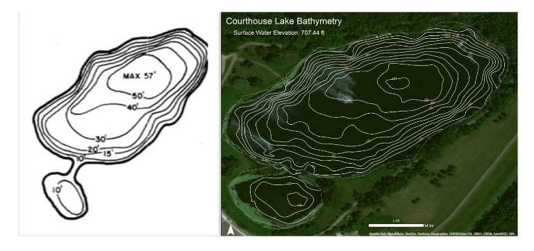
Courthouse Lake is a former clay mine in the city of Chaska that was abandoned and has since filled with water. It is 57 feet (17 meters) deep and 12 acres in area. It is managed as a Class 2A water for cold-water fish and aquatic life. It is stocked with trout by the MNDNR.
Courthouse Lake has a pier and is popular for fishing, but it has limited access for boating.
The adjacent graphic shows the depth (i.e., bathymetry) of Courthouse Lake. The bathymetry on the left was published by the U.S. Geological Survey (Tornes, 1981), and the graphic on the right was produced by the Carver County Watershed Management Organization.
Land Use
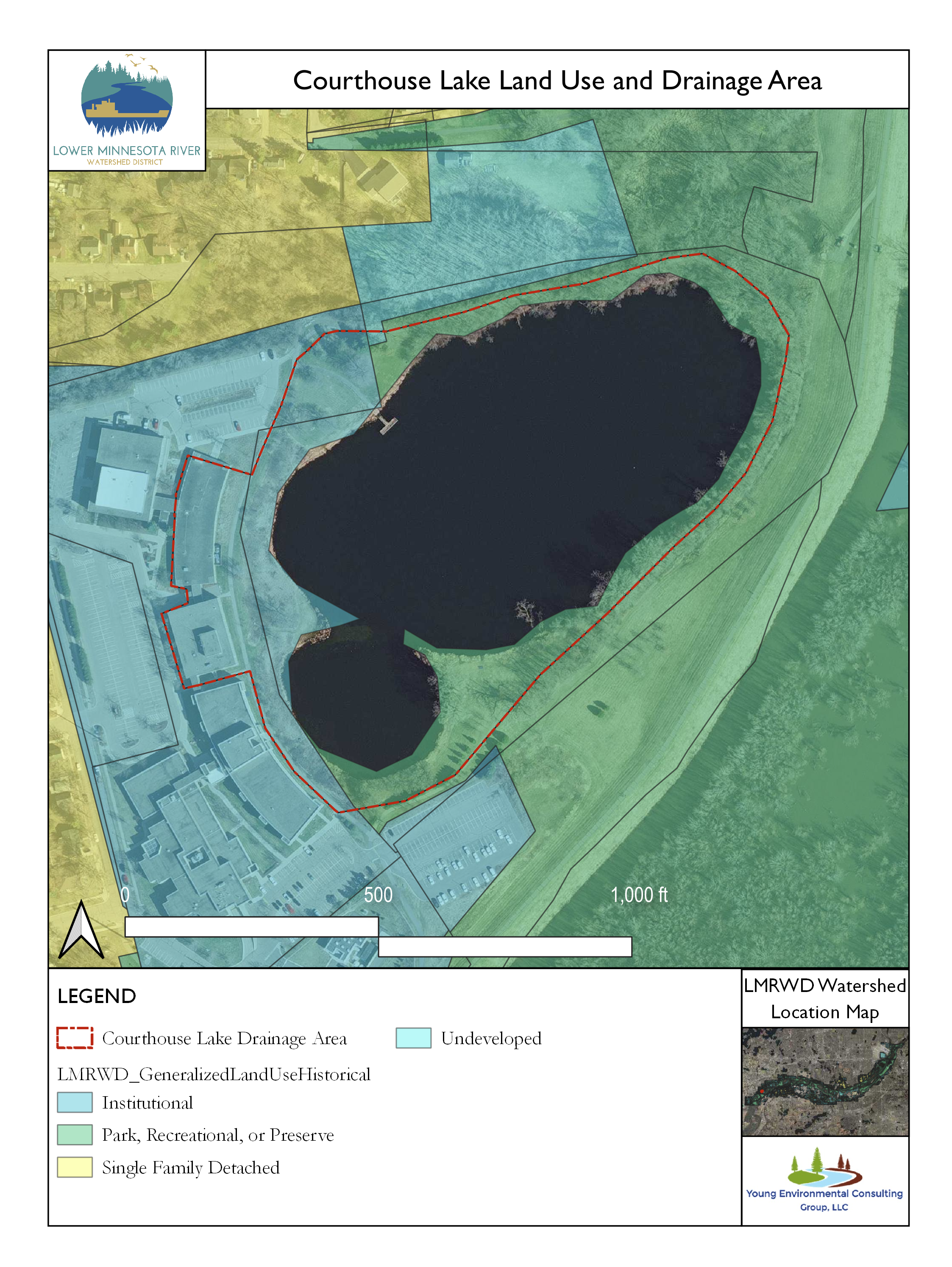
The area of land that drains overland water flow (e.g., rainfall, snowmelt) to Courthouse Lake is shown in the adjacent graphic. Much of the area draining into the lake consists of institutional land with parkland comprising much of the rest.
Monitoring Data
Dissolved Chloride
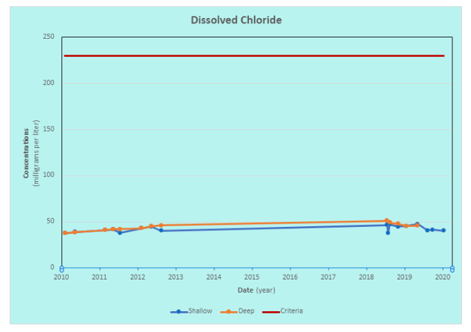
Concentrations of dissolved chloride in Courthouse Lake are usually below 50 milligrams per liter (mg/L). This level of chloride is well below the state of Minnesota 230 mg/L criteria (Statutes, 2021), shown by the red line on the graph. However, concentrations are greater than they were in the early 2000s decade, when they rarely exceeded 20 mg/L. Samples collected near the surface of the lake, which are shown in blue and labeled “Shallow,” have been often accompanied in recent years by samples collected near the bottom, which are shown in orange and labeled “Deep.” The chloride concentration was nearly the same in both shallow and deep samples, suggesting that the shallow and deep waters mix. There are numerous sources of chloride stated in the Minnesota Statewide Chloride Management Plan, such as salt applied to roads, parking lots, and sidewalks; water softener discharge; agricultural fertilizer; and industrial discharge, to name a few (MPCA, 2021).
Transparency
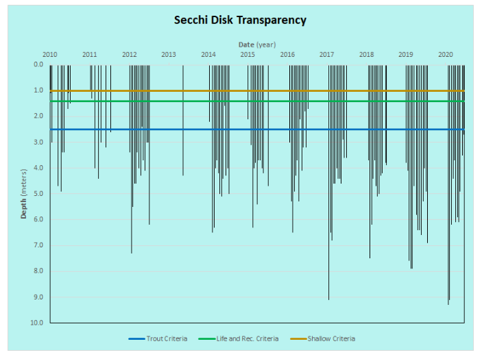
The transparency, a measure of water clarity, of Courthouse Lake is good—often over 4 meters (13 feet). Many of the readings exceed the 2.5-meter criteria for Class 2A trout lakes in Minnesota (Statutes, 2021) and have exceeded 9 meters (almost 30 feet) in recent years.
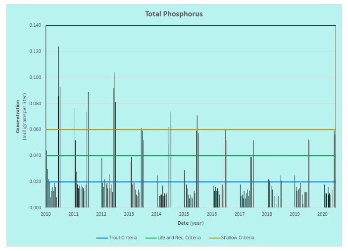
Total Phosphorus
Total phosphorus concentrations in Courthouse Lake averaged 0.026 mg/L, which is below the limit for Class 2 waters in Minnesota shown by the green line on the graph below. The median (i.e., middle value), 0.016 mg/L, is within the class 2A trout waters criteria shown by the blue line. Phosphorous is necessary for plant life, but too much can cause an increase in aquatic plant growth that uses up oxygen needed by fish and other aquatic life.
Water Temperature and Dissolved Oxygen
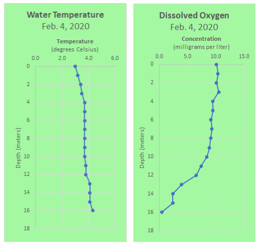
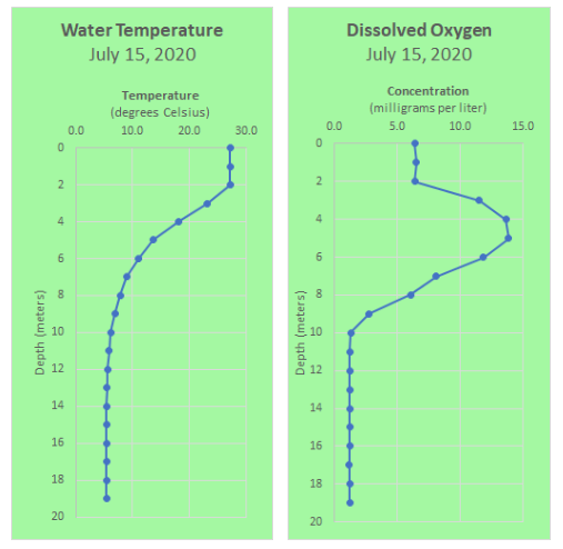
Water temperature and dissolved oxygen (DO) are measured at selected depths in Courthouse Lake several times each year. Measurements taken during the winter and summer of 2020 showed how temperature and DO concentrations at different depths change with the seasons.
In the winter, under ice cover, the temperature is coldest near the surface ice and warms toward the bottom as the dense, 4.0 degree Celsius water settles near the bottom. DO is highest near the surface and used up by respiration deeper in the water column. If the DO level gets too low while the lake water is isolated under ice cover, fish and other organisms could be stressed or killed.
Like many other deep lakes, Courthouse Lake begins developing stratification (i.e., layering) in the spring with well-oxygenated water at the surface and low oxygen water near the bottom. Starting at about 2 meters (6.6 feet) in July, the DO level was higher because increased amounts of algae and other plant life produced excess oxygen. At a greater depth, below about 10 meters (33 feet), the oxygen can be used up as organic matter decomposes. As fall approaches, cool weather and wind will cause the lake waters to mix, resulting in a more uniform temperature and DO concentration.
Because Courthouse Lake is deep enough to stratify, it may have better water quality than other lakes in an urban setting. Extra phosphorus tends to fall to the dark, cold bottom waters, where it is isolated from the more productive surface waters. Mixing in the fall disrupts that isolation and can bring extra phosphorus to the surface.
Controlling overland water flow to Courthouse Lake may help reduce chloride, sediment, and phosphorus from reaching the lake. This may explain the high transparency and good-quality habitat found in the lake.
In 2020, the Carver County Water Management Organization (CCWMO) conducted an aquatic vegetation survey on Courthouse Lake, sampling for the abundance of several species of large aquatic plants. You can view that survey and others at the CCWMO’s aquatic vegetation survey webpage.
References
MPCA. (2021). MPCA Chloride Management Plan. Retrieved from https://www.pca.state.mn.us/sites/default/files/wq-s1-94a.pdf
Statutes, M. (2021, August 10). Minnesota Administrative Rules 7050.0222. Retrieved from https://www.revisor.mn.gov/rules/7050.0222/
Tornes, L. (1981). Quality of Surface Water Before Implementation of a Flood-control Project in Chaska, Minnesota. St. Paul, Minnesota: U.S. Geological Survey.