Stream ID
Minnesota Department of Natural Resources (MNDNR) stream ID M-055-009. This link provides available information on stream location, characteristics, and fisheries.
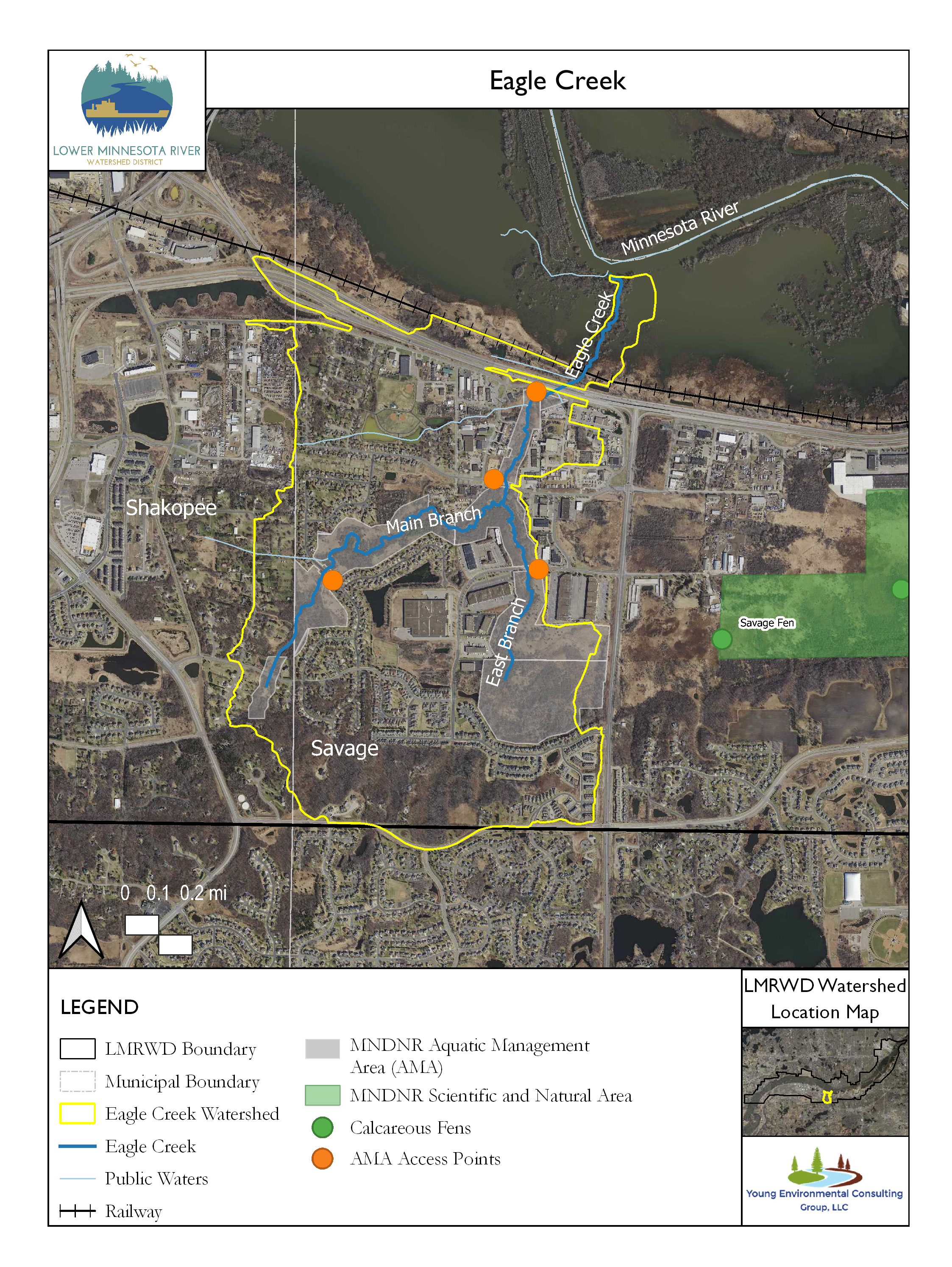
Eagle Creek is a 2.19-mile (3.5-kilometer) MNDNR-designated trout stream in Scott County within the cities of Savage and Shakopee, Minnesota, and a tributary to the Minnesota River. The main (west) branch of Eagle Creek begins near Boiling Springs and flows through residential areas in the sloped upper reaches. Boiling Springs is a unique feature within the Eagle Creek watershed. Known to the Dakota people as Maka Yusota, it was added to the US National Register of Historic Places in 2003 because of its cultural importance. It is named “Boiling Springs” because the upwelling of groundwater forces sand to the surface of a pool in the creek, giving it the appearance of boiling water (Anfinson 2003). After Boiling Springs, Eagle Creek runs north where it meets the similarly sloped east branch, which starts near the Savage Fen complex, just south of West 126th Street in Savage. Two tributary streams from the west, which are not designated trout waters, join Eagle Creek and likely contribute runoff to its flow. The northernmost stream is mainly confined to an underground pipe until it reaches the creek. Eagle Creek continues to flow north, under Highway 13 and the Union Pacific railroad crossings, onto the relatively flat floodplain of the Minnesota River, where it is no longer a designated trout stream.
In the early 1990s, the area around Eagle Creek was designated as Minnesota’s first aquatic management area (AMA). The AMA creates a buffer around Eagle Creek to protect the stream from future development and provides angler and management access (MNDNR 2021). One of these accesses is a small parking lot located south of State Highway 101 along the frontage road. Three other access points are via roadside pull-offs along Independence Avenue, West 126th Street, and Eagle Creek Parkway (MNDNR n.d.).
Eagle Creek has a self-sustaining resident brown trout population. More than half of the stream is considered suitable for stream trout (MNDNR 2020). The creek was managed as a stocked, put-and-take trout fishery from 1945 to 1978, meaning most fish were harvested soon after stocking. Rainbow trout were stocked regularly from 1945 to 1966, then sporadically until 1974 (Willey 2002). The MNDNR has not stocked Eagle Creek since 1978.
Land Use
Current land use is predominantly park, recreational, or preserve, with the 233-acre AMA dominating the Eagle Creek watershed. Single-family residential makes up most of the main branch watershed, whereas the lower and east branches near the creek are a mix of commercial to the east and residential to the west. Light industrial and commercial development is more common where the creek intersects Highway 13. The land north of Highway 13 and the Union Pacific railroad is within the Minnesota Valley Wildlife Refuge. Future land use will generally transition from open space and agricultural to residential and mixed-use, commercial, and industrial.
Monitoring Data
The Lower Minnesota River Watershed District funds routine creek sampling by the Scott County Soil and Water Conservation District under the direction of the Metropolitan Council of Environmental Services (MCES). The sampling site is at the West 125th Street bridge crossing below, where the east and main branches meet and before the stream enters the floodplain of the Minnesota River. Selected results from the analysis of individually collected samples from Eagle Creek were obtained from the MCES websitei and are summarized in the following graphs.
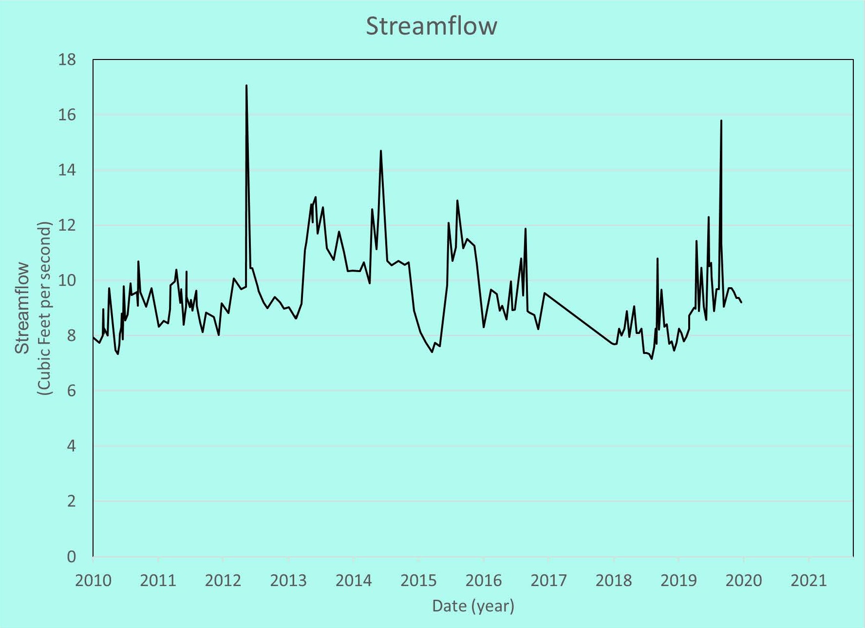
Streamflow
The streamflow of Eagle Creek, when samples were collected, is shown below. The range in streamflow is not significant because the creek is mainly fed by a steady discharge of groundwater with little surface drainage contributing to runoff that would add to the variability, or “flashiness,” of the creek. There are no aquatic life criteria for streamflow, but sustained streamflow ensures other habitat characteristics such as flow velocity and water depth are optimal for trout.
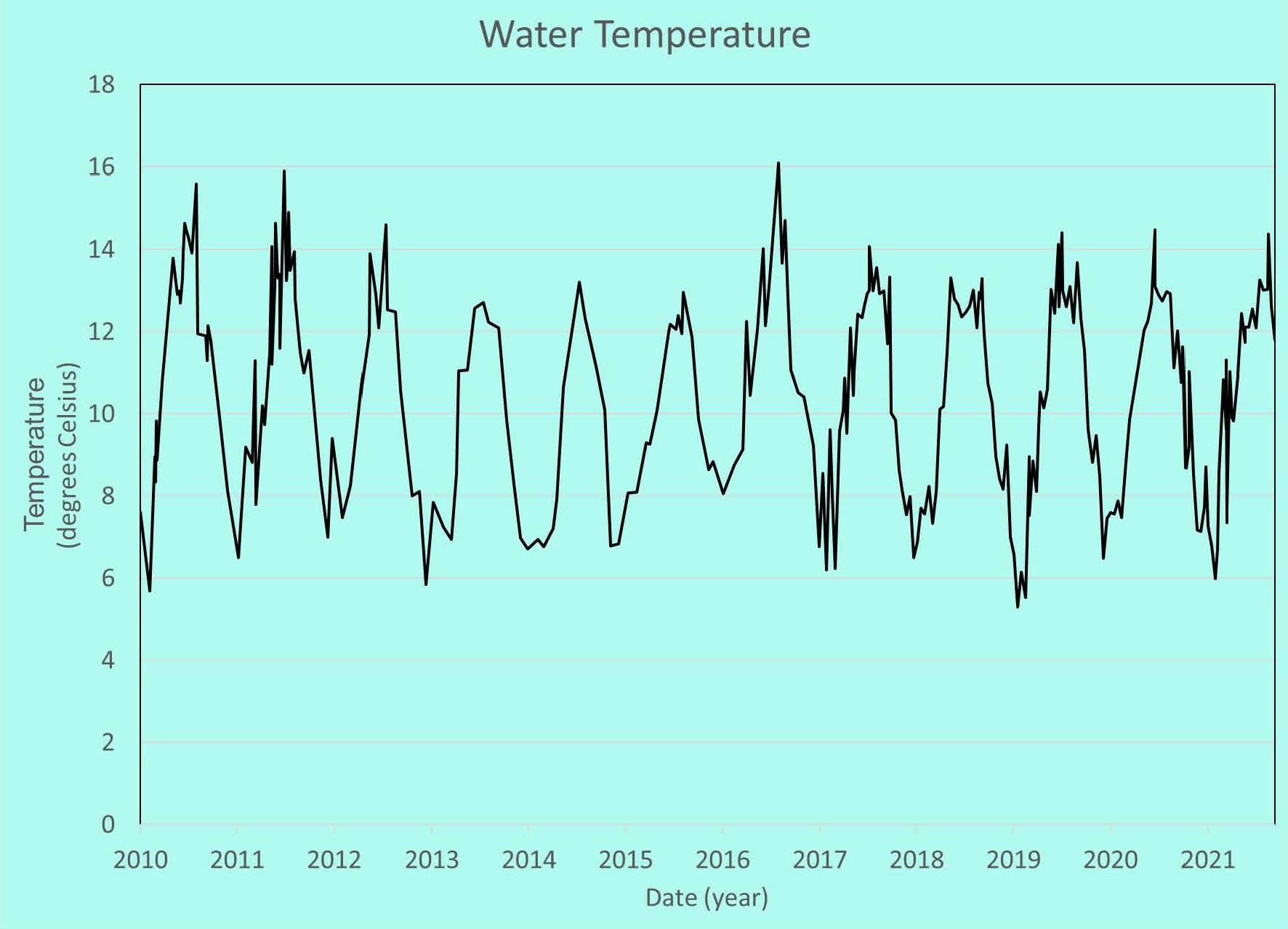
Water Temperature
The water temperature of Eagle Creek is important for the habitat because trout and other fish and aquatic life become stressed when the water is too warm. Trout need cold water and cannot tolerate temperatures above 75 degrees Fahrenheit [°F] (24 Celsius [°C]) for long (MNDNR 2021). Warm water holds less dissolved oxygen than is needed by aquatic organisms. Temperatures at the sampling sites fluctuate seasonally, approaching 61°F (16°C) in the summer and 43°F (6°C) in the winter. Because Eagle Creek is spring-fed by relatively warm groundwater, temperatures in the winter stay well above the 32°F (0°C) freezing point.
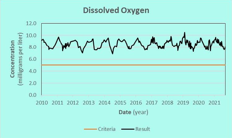
Dissolved Oxygen
Measurements of dissolved oxygen (DO) concentration show that Eagle Creek remains well oxygenated. Trout typically need at least 5 mg/L of DO (MNDNR 2021). The narrow range of fluctuation in DO concentration helps maintain a healthy, low-stress habitat.
Transparency
The transparency, a measure of water clarity, of Eagle Creek is shown in the following graph. High transparency in a stream indicates clear water that is not carrying a lot of the fine material that is detrimental to the trout habitat and can smother spawning beds. Low transparency suggests that a lot of sediment is carried by the stream, which may be associated with other contaminants and could harm the trout habitat. The transparency of Eagle Creek water often exceeded the length of the transparency tube (the device used to measure the transparency). Most of the readings between 2010 and 2012 were greater than the 60-cm length of the tube. The 100-cm tube, which started to be used in 2012, was also inadequate for many measurements because the mostly spring-fed creek was so clear. Drops in transparency suggest that changes in flow from runoff or other influences have resulted in the stream carrying more sediments. Most aquatic life can tolerate and quickly recover from brief periods of increased sediment.
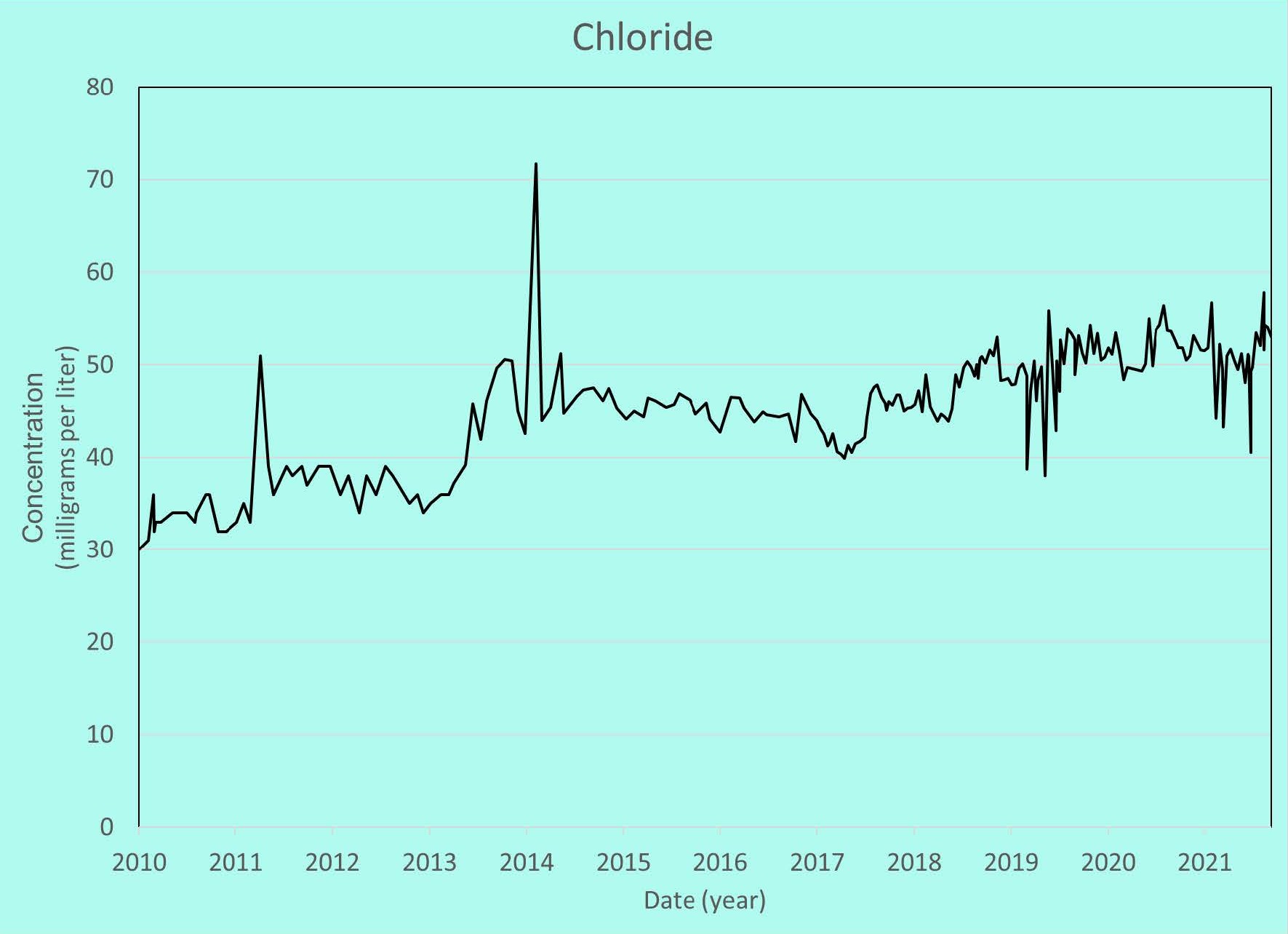
Chloride
Chloride, a primary component of road deicing and water-softening salt, is a growing concern for many streams and lakes. The chronic standard for chloride in Minnesota waters to protect both cool and warm water aquatic life is 230 mg/L (MPCA 2018). The chronic standard is defined in Minnesota Rules 7050.0218, subpart 3.l. as “the highest water concentration of a toxicant to which organisms can be exposed indefinitely without causing chronic toxicity.” Chloride concentrations in Eagle Creek are well below the chronic standard but have trended upward over the past 10 years.
A detailed discussion of Eagle Creek’s resources is provided in the Trout Streams Gaps Analysis and Management Plan that, as of this writing, will soon be published (Young 2022). It provides an insightful discussion of the creek’s history, morphometry, and fisheries.
This data was last updated June 2022.
References
Anfinson, Scott. 2003. “Minnesota Preservation Planner.” Minnesota Historical Society. April. Accessed December 11, 2020. http://www2.mnhs.org/about/publications/planner/Spring2003.pdf.
MNDNR. 2021. Eagle Creek. Accessed Oct 4, 2021. https://www.dnr.state.mn.us/streamfind/stream.html?id=M-055-009.
—. n.d. Eagle Creek Access Map. Accessed Oct 4, 2021. https://files.dnr.state.mn.us/areas/fisheries/westmetro/ec_access_points.pdf.
—. 2021. Stream basics | Minnesota DNR. Accessed Nov 3, 2021. https://www.dnr.state.mn.us/fishing/trout_streams/stream_basics.html.
MPCA. 2018. TCMA Chloride TMDL - Applicable Water Quality Standards and Numeric Water Quality Targets. May 18. Accessed Nov 8, 2021. https://stormwater.pca.state.mn.us/index.php/TCMA_Chloride_TMDL_-_Applicable_Water_Quality_Standards_and_Numeric_Water_Quality_Targets.
Willey, Scott. 2002. “Minnesota Department of Natural Resources: River or Stream Survey.”
Young, Environmental. 2022. Trout Streams Gaps Analysis and Management Plan - Draft Report. Resource Investigation, Chaska, MN: Lower Minnesota River Watershed District.
i “NOTICE: Data are made available pursuant to the Minnesota Government Data Practices Act (Minnesota Statutes Chapter 13). THE DATA ARE PROVIDED TO YOU AS IS AND WITHOUT ANY WARRANTY AS TO THEIR PERFORMANCE, MERCHANTABILITY, OR FITNESS FOR ANY PARTICULAR PURPOSE. These data were developed by the Metropolitan Council for its own business purposes. The Metropolitan Council makes every effort to ensure the data and associated documentation are error-free, complete, current, and accurate; however, the Metropolitan Council does not guarantee this. The Metropolitan Council is NOT responsible for any consequences resulting from your use of the data. You should consult the available online documentation or contact the staff contact listed in the EIMS data catalog to determine the limitations of the data. If you transmit or provide the data, or any portion of it, to another user, the data must include a copy of this disclaimer.”