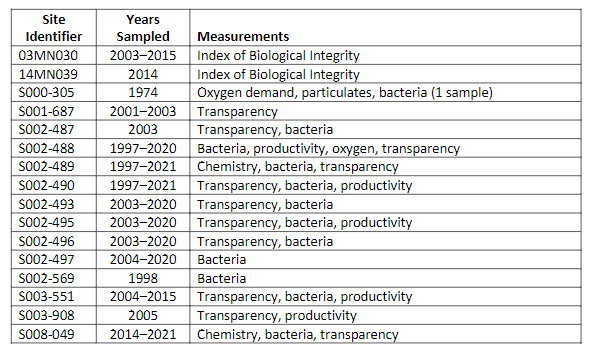
Stream ID
Minnesota Department of Natural Resources (MNDNR) stream ID M-055-022
Minnesota Pollution Control Agency (MPCA) stream ID S002-489. This link provides available information on stream quality. Although this is the most downstream comprehensive sampling site, Carver Creek also has other sites that were sampled for studies whose data are identified in the adjacent table.
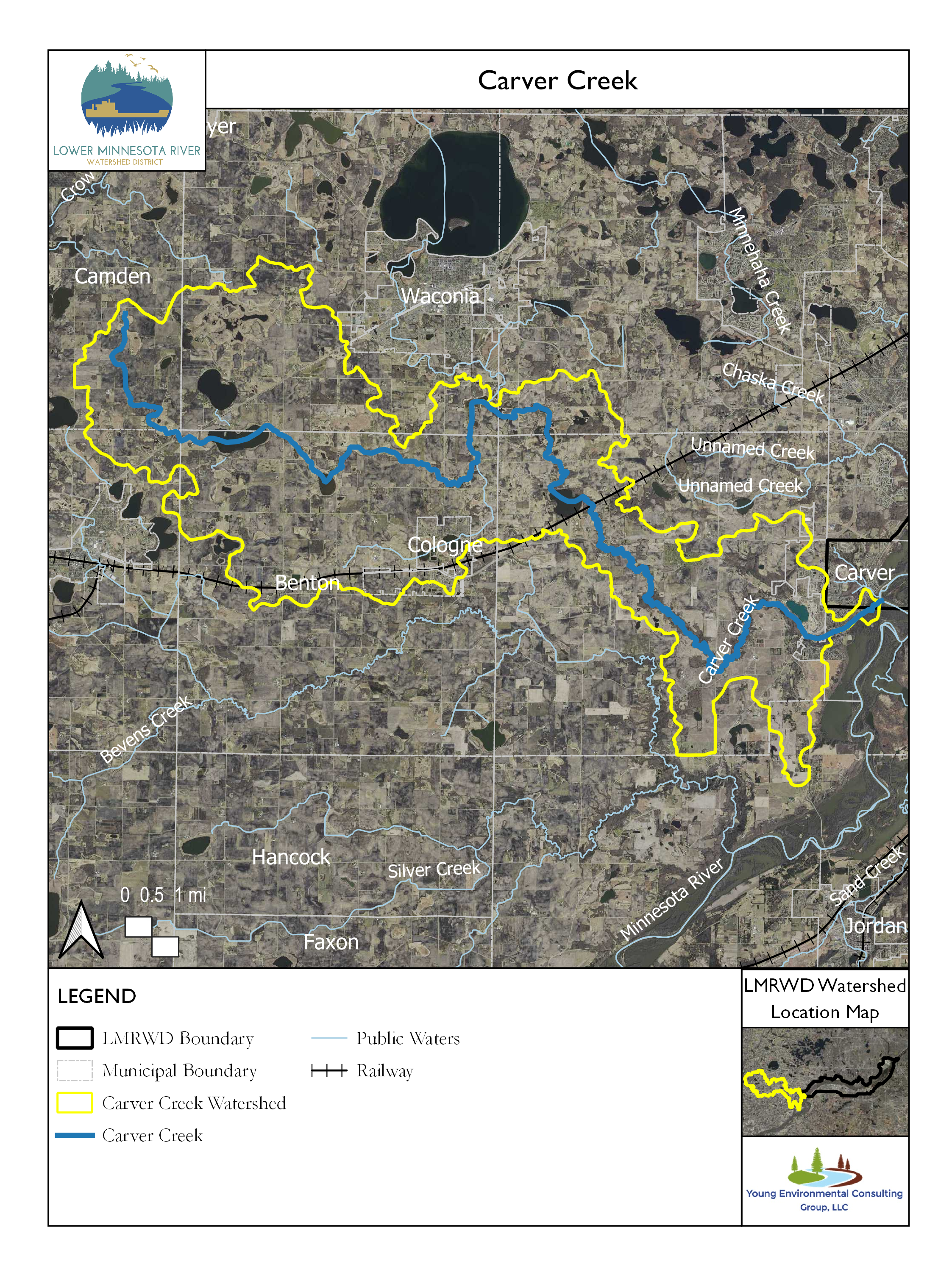
Carver Creek is a 31-mile- (50-kilometer-) long stream located in the western Twin Cities metropolitan area that drains 83 square miles (21,500 hectares) (MCES 2014). It has two headwater branches, one in Waconia Township and one in Camden Township. The creek runs through lakes (including Lake Waconia), wetlands, and the Minnesota Valley National Wildlife Refuge, before discharging into the Minnesota River. Current land use is mostly agricultural (53%), followed by undeveloped (24%), and recreation and open water (12%). Carver Creek aquatic life is impaired because of nutrient concentrations and turbidity and has also been identified as impaired on the basis of benthic macroinvertebrate and fish bioassessments (MPCA 2022). Carver Creek aquatic recreation is impaired because of fecal coliform contamination (MPCA 2022). Most of the watershed is outside the Lower Minnesota River Watershed District except near its mouth in the City of Carver.
Selected results from the analysis of samples collected from Carver Creek at a site 1.7 miles upstream from where Carver Creek joins the Minnesota River were obtained from the Metropolitan Council Environmental Services (MCES) websitei and are summarized in the following graphs. Data from the MCES website suggest a partnership with the Carver Creek Water Management Organization (CCWMO), whereas the MPCA data do not. This suggests that the MPCA samples were collected for special studies unrelated to a collaboration between the MCES and the CCWMO.
Monitoring Data
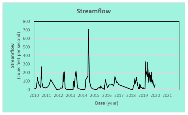
Streamflow
Samples collected from Carver Creek’s streamflow are shown in the adjacent graph. The creek’s flow rarely drops below 1 cubic foot (0.028 cubic meters) per second. Although sampling continued through 2021, the streamflow values had not been recorded when the data were downloaded on March 17, 2022.
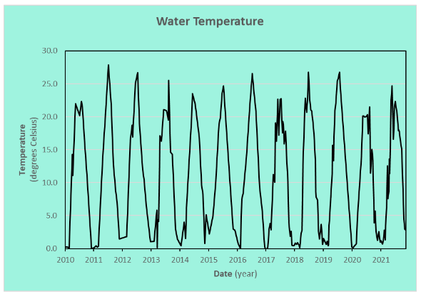
Water Temperature
The water temperature of Carver Creek is important because warmer water holds less of the dissolved oxygen (DO) needed by many aquatic organisms. Creek temperatures fluctuate seasonally, occasionally exceeding 77° Fahrenheit (25° Celsius) in the summer and stays near 32°F (0° Celsius) in the winter.
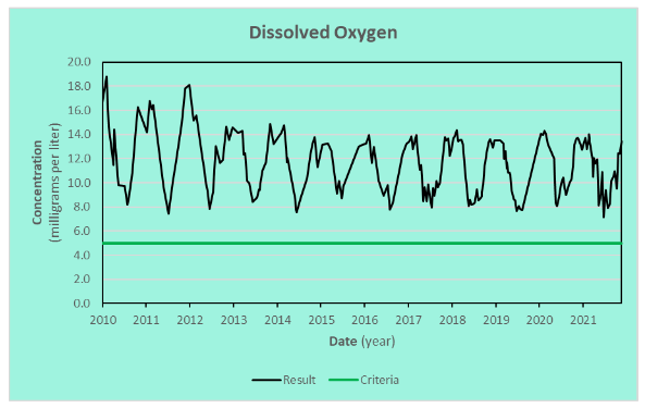
Dissolved Oxygen
DO concentration measurements show that Carver Creek remains well oxygenated. Aquatic animals typically need at least 5 mg/L of DO (MNDNR 2021). Seasonal fluctuations are normal because oxygen solubility changes with water temperature.
Turbidity
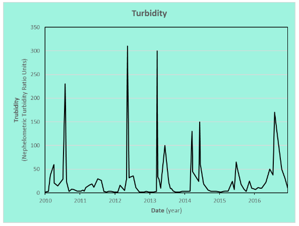
The following graph shows the turbidity, a measure of water clarity, of Carver Creek. High turbidity in a stream indicates cloudy water that carries greater amounts of fine sediment, which interferes with visibility. Low turbidity implies that less sediment is carried by the stream. Streams receiving runoff tend to be turbid while they might otherwise run clear.
Chloride
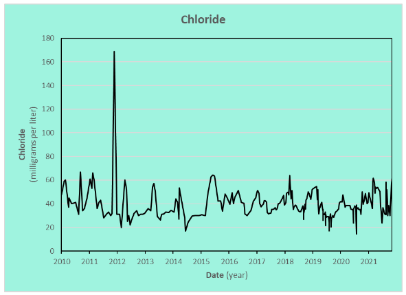
Chloride, a primary component of road-deicing and water-softening salt, represents a growing concern for many streams and lakes. The chronic standard for chloride in Minnesota waters to protect cool and warm water fisheries is 230 mg/L (MPCA 2018). Chloride concentrations measured in Carver Creek were consistently below the chronic standard, so the standard is not shown on the graph. The highest concentration, 169 milligrams per liter, was measured in a sample collected on December 7, 2011.
Phosphorus
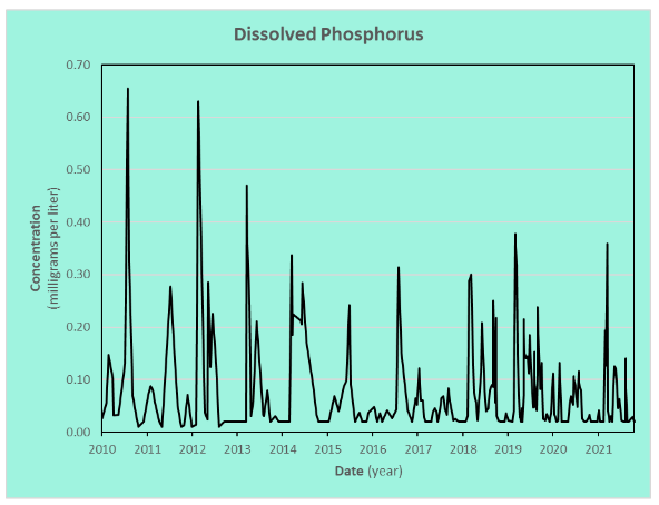
Phosphorus is an essential plant nutrient that is carried by streams. Naturally occurring phosphorus concentrations may be enriched from animal waste and fertilizers, and phosphorus is often introduced with runoff. Phosphorus is often associated with sediment but is more available to plants when dissolved in the water. The chart below shows the phosphorus concentrations in samples from Carver Creek after the water has been filtered to remove the sediment-associated phosphorus.
References
CCWMO. 2021. 2020 Monitoring Report of the Carver Creek Watershed. Story Map, Chaska, MN: Carver County Water Management Organization. Accessed December 1, 2021. https://storymaps.arcgis.com/stories/df6616b4a0b84c81befb7b86dfc59026.
MCES. 2014. Carver Creek Fact Sheet. Fact Sheet, St. Paul, MN: Metropolitan Council. https://metrocouncil.org/Wastewater-Water/Services/Water-Quality-Management/Stream-Monitoring-Assessment/Minnesota-River-Tributary-Streams-Assessment/Mn-River-Trib-Assessment-Reports/Carver-Creek-Factsheet.aspx.
MNDNR. 2021. Stream Basics. Minnesota DNR. Accessed November 3, 2021. https://www.dnr.state.mn.us/fishing/trout_streams/stream_basics.html.
MPCA. 2018. TCMA Chloride TMDL—Applicable Water Quality Standards and Numeric Water Quality Targets. May 18. Accessed November 8, 2021. https://stormwater.pca.state.mn.us/index.php/TCMA_Chloride_TMDL_-_Applicable_Water_Quality_Standards_and_Numeric_Water_Quality_Targets.
This data was last updated December 2021.