Lake ID
Minnesota Department of Natural Resources (MNDNR) site ID 10022500. This link provides information on lake location, morphometry, and fisheries.
Minnesota Pollution Control Agency site ID 10-0225-00-201. This link provides information on lake chemistry.
Brickyard Clayhole Lake, also known as Brickyard Lake or Clayhole Lake, is a former clay mine in the city of Chaska that was abandoned and has since filled with water. It is nearly 40 feet (12 meters) deep and is managed as a Class 2B water for cool- and warm-water fish and aquatic life. Brickyard Clayhole has been considered for management as a Class 2A water, which sustains a healthy community of cold-water aquatic life. In general, Class 2 waters support aquatic life and provide recreation opportunities.
Brickyard Clayhole Lake has a pier and is popular for fishing but has limited access for boating. The last MNDNR Fisheries survey of Brickyard Clayhole Lake was completed in 1984. Since that time, lake conditions and fish populations have changed because of altered connections to the Minnesota River. There have been no recent reports of river-origin fish in the lake, which there had been in the past. In 2008–2016, an ice fishing contest for all legal game fish was held on the lake. Reports indicated largemouth bass, bluegill, black crappie, yellow perch, and other sunfish species and hybrids were caught. The contest has been canceled several times in recent years because of unsafe ice conditions (MNDNR, 2021).
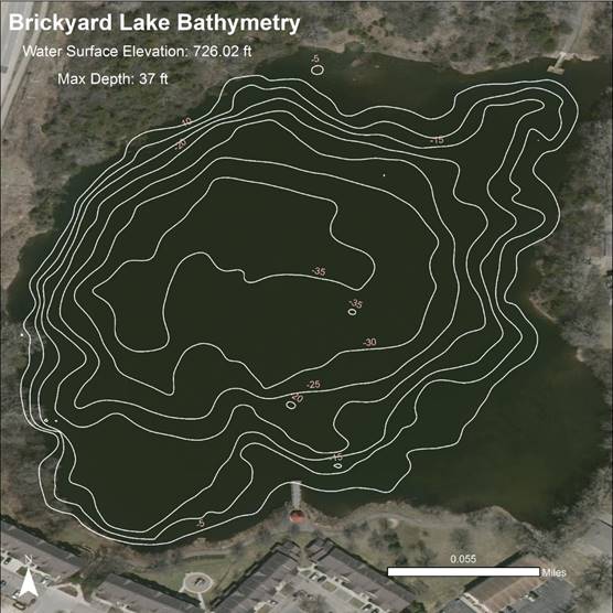
The adjacent graphic shows the depth (bathymetry) of Brickyard Clayhole Lake measured by the Carver County Watershed Management Organization. The maximum depth shown is 37 feet, but greater depths have been measured.
Land Use
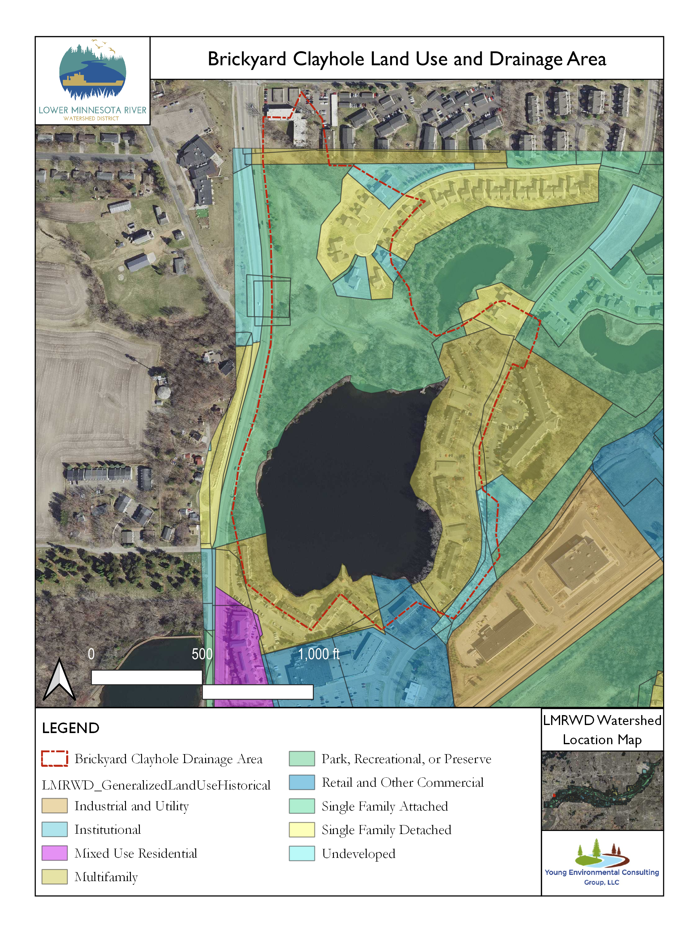
The area of land that drains overland water flow (e.g., rainfall, snowmelt) to Brickyard Clayhole Lake is shown in the adjacent graphic. Much of the area draining to the lake consists of single and multifamily homes with parkland to the north and west.
Monitoring Data
Chloride
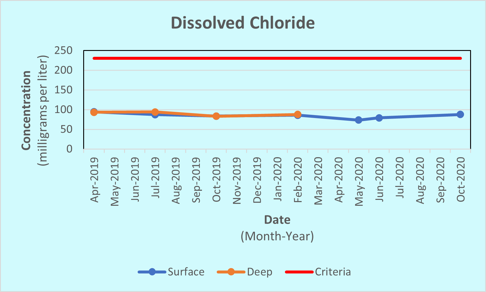
The concentrations of dissolved chloride are below 100 mg/L in Brickyard Clayhole Lake. This level of chloride is well below the state of Minnesota 230 mg/L standard (Statutes, 2021), as shown by the red line on the graph. Samples collected near the surface of the lake, shown in blue, were accompanied by samples collected near the bottom, shown in orange and labeled ‘Deep,’ in 2019 and early 2020. The chloride concentration was nearly the same in surface and deep samples. This indicates that the shallow and deep waters mix. There are numerous sources of chloride, as stated in the Minnesota Statewide Chloride Management Plan, such as from salt applied to roads, parking lots, sidewalks; water softener discharge; agricultural fertilizer; and industrial discharge to name a few (MPCA, 2021).
Transparency
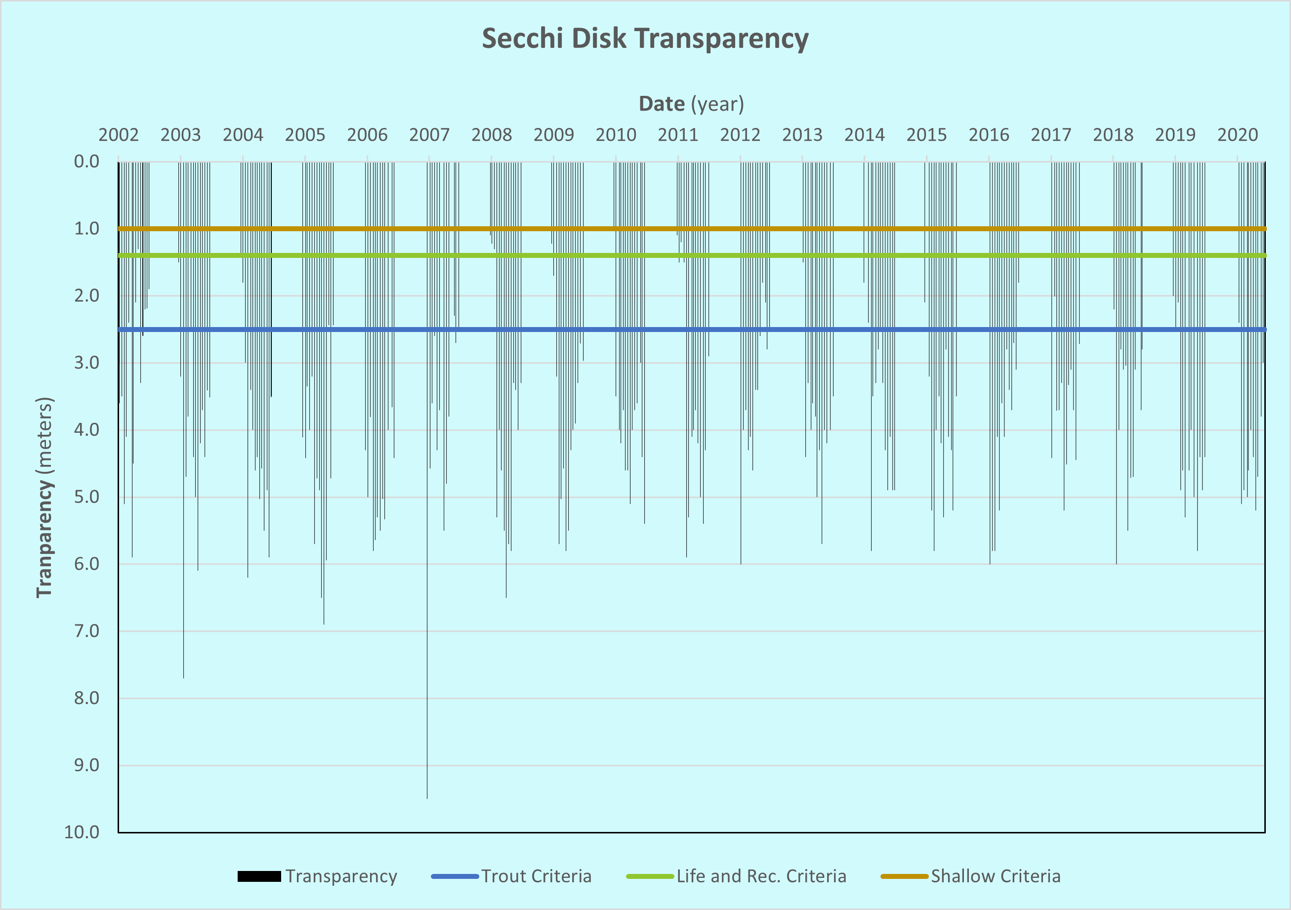
The transparency, a measure of water clarity, of Brickyard Clayhole Lake is good—often over 4 meters (13 feet). Many of the readings exceed the 2.5-meter criteria for class 2A trout lakes in Minnesota (Statutes, 2021).
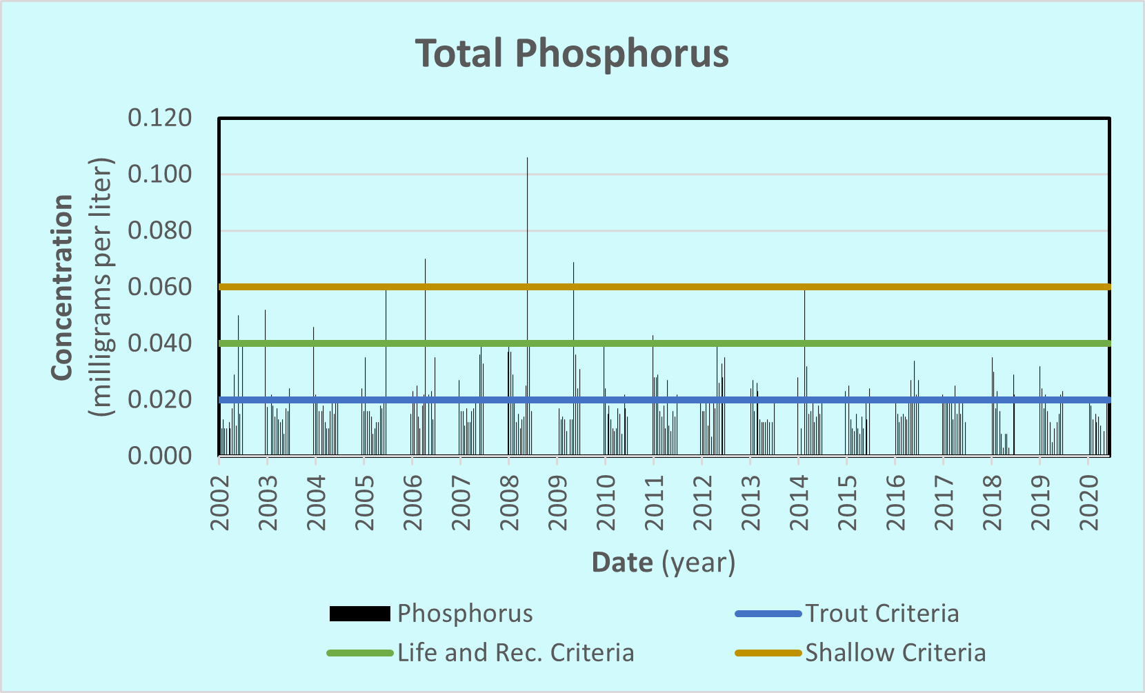
Total Phosphorus
Total phosphorus concentrations in Brickyard Clayhole Lake average around 0.018 mg/L, which is below the limit for Class 2 waters in Minnesota. This is shown by the green line on the graph. Since 2015, concentrations have routinely been within the criteria needed to maintain aquatic life and recreation, and were often within the Class 2A trout waters criteria, shown by the blue line. Phosphorous is necessary for plant life, but too much can cause an increase in aquatic plant growth that uses up oxygen needed by fish and other aquatic life.
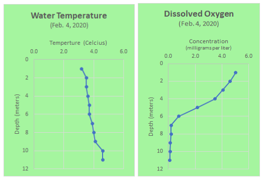
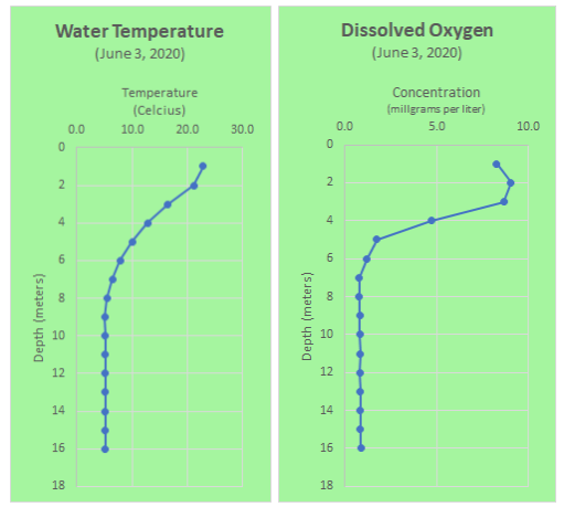
Water Temperature
Water temperature and dissolved oxygen (DO) are measured at selected depths in Brickyard Clayhole Lake several times each year. Measurements taken during the winter and summer of 2020 show how temperature and DO concentrations at different depths change with the seasons.
In the winter, under ice cover, the temperature is coldest near the surface ice and warms toward the bottom as the dense, 4.0 degrees Celsius water sinks to the bottom. DO is highest near the surface and is used up by respiration deeper in the water column. If DO gets too low while the lake water is isolated under ice cover, fish and other organisms could be stressed or killed.
In the summer, warm water is near the surface, whereas dense, cold water stays near the bottom. This thermal stratification (i.e., layering) keeps well-oxygenated water at the surface and lower oxygen water near the bottom. In June, at about 2 meters, the DO level was higher because increased amounts of algae and other plant life produced excess oxygen. At greater depths, the oxygen can be used up as organic matter decomposes.
Because Brickyard Clayhole Lake is deep enough to stratify, it may have better water quality than other lakes in an urban setting. Extra phosphorus tends to fall to the dark, cold bottom waters, where it is isolated from the more productive surface waters.
Controlling overland water flow to Brickyard Clayhole Lake may help reduce chloride, sediment, and phosphorus reaching the lake. This may explain the high-transparency and good-quality habitat in the lake.
In 2019, the Carver County Water Management Organization (CCWMO) conducted an aquatic vegetation survey on Brickyard Clayhole Lake, sampling for the abundance of several species of large aquatic plants. You can view that survey and others at the CCWMO’s aquatic vegetation survey webpage.
References
MNDNR. (2021, August 10). Brickyard Clayhole Lake. Retrieved from Lakefinder: https://www.dnr.state.mn.us/lakefind/lake.html?id=10022500
MPCA. (2021). MPCA Chloride Management Plan. Retrieved from https://www.pca.state.mn.us/sites/default/files/wq-s1-94a.pdf
Statutes, M. (2021, August 10). Minnesota Administrative Rules 7050.0222. Retrieved from https://www.revisor.mn.gov/rules/7050.0222/
This data was last updated October 2021.