photo: Tim Kiser
Stream ID
Minnesota Department of Natural Resources (MNDNR) stream ID M-055-007
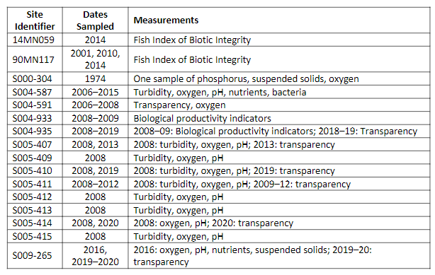
Minnesota Pollution Control Agency (MPCA) sites for Credit River are listed in the adjacent table. The table also identifies when and what measurements were made at the site. Those data can be accessed at https://webapp.pca.state.mn.us/surface-water. Although many sites were sampled, most of the sites are near each other in a park in Savage, approximately two miles (three kilometers) upstream from the confluence with the Minnesota River.
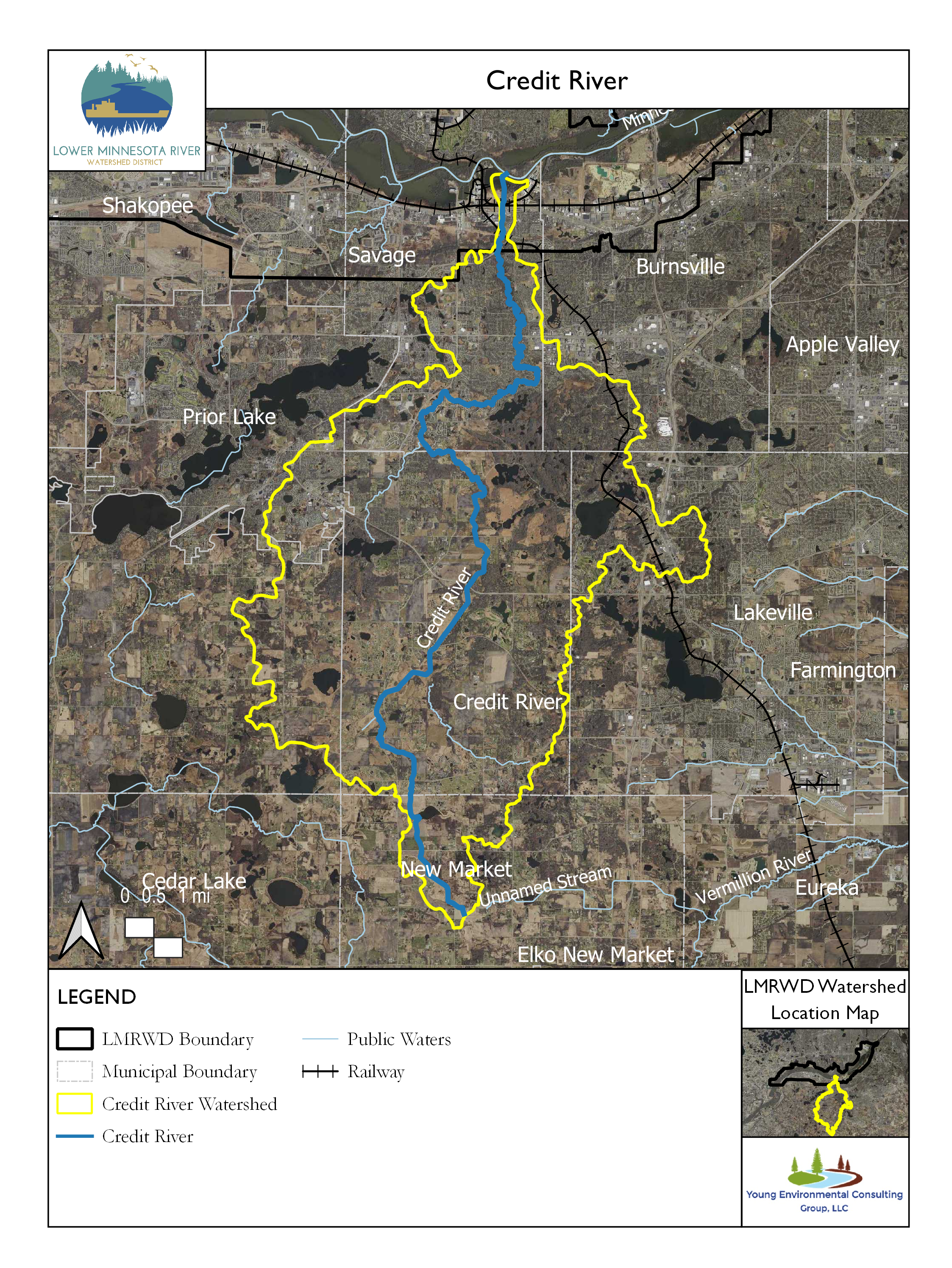
Credit River is a 21.5-mile- (34 kilometer-) long stream located in Scott County, Minnesota, that drains a 47-square-mile (12,200-hectare) watershed (MCES 2014). After flowing from the south through Savage, Minnesota, it empties into the Minnesota River. Upstream of the sampling site in Savage, land use is about 25% urban, 50% range and forest, and 15% agricultural, with the rest being water and wetland. Only the downstream portion of the river, near the city of Savage, is in the Lower Minnesota River Watershed District.
Credit River is impaired for aquatic life based on the results of benthic macroinvertebrate and fish bioassessments. Chloride concentrations also are a detriment to aquatic life. Aquatic recreation in the river is impaired because of Escherichia coli (E. coli) levels (MPCA 2022).
Credit River is sampled by the Metropolitan Council Environmental Services (MCES) as part of the Comprehensive Water Quality Assessment of Select Metropolitan Area Streams (MCES 2014). Selected results from the analysis of samples collected at a site in Savage, Minnesota, 0.9 miles (1.4 kilometers) above its mouth were obtained from the websitei and are summarized in the following graphs.
Monitoring Data
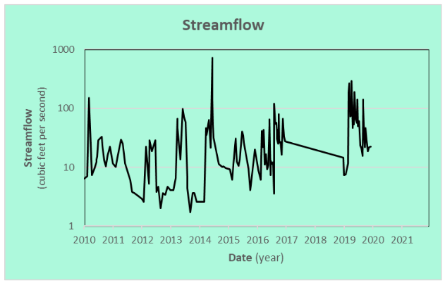
Streamflow
Samples collected from Credit River’s streamflow are adjacent. The creek’s flow ranged from 1.7 to 732 cubic feet (0.048 to 20.7 cubic meters) per second. The most common flow during sampling was about 37 cubic feet (1.05 cubic meters) per second.
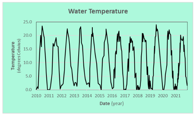
Water Temperature
The water temperature of Credit River is important because warmer water holds less dissolved oxygen (DO) needed by many aquatic organisms. Creek temperatures fluctuate seasonally approaching 77° Fahrenheit (25° Celsius) in the summer and falling near 32° F (0° C) in the winter.
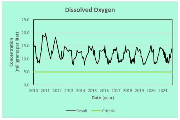
Dissolved Oxygen
DO concentration measurements show that Credit River remains well oxygenated. Aquatic animals typically need at least 5 mg/L of DO (MNDNR 2021). Seasonal fluctuations are normal because oxygen solubility changes with water temperature.
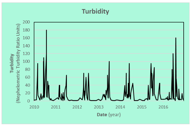
Turbidity
The adjacent graph shows the turbidity, a measure of water clarity, of Credit River. High turbidity in a stream indicates cloudy water carrying large amounts of fine sediment that interferes with visibility. Low turbidity implies that less sediment is carried by the stream. Streams receiving runoff tend to be turbid when they might otherwise run clear.
Various methods have been used since 2010 to measure turbidity in Credit River, and the results using different methods are not comparable. Only the measurements reported in nephelometric turbidity ratio units (NTUs) are shown in the chart.
Chloride
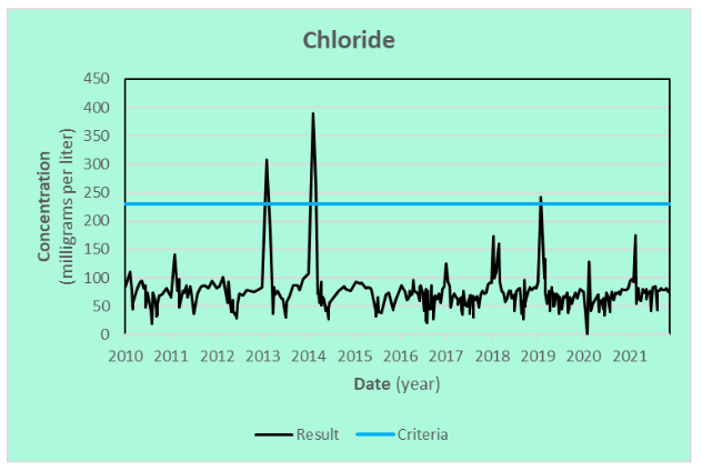
Chloride, a primary component of road deicing and water-softening salt, represents a growing concern for many streams and lakes. The chronic standard for chloride in Minnesota waters to protect cool and warm water fisheries is 230 mg/L (MPCA 2018). Chloride concentrations measured in Credit River are usually far below the chronic standard but occasionally exceed the standard. Peak concentrations were measured in the winter.
Phosphorus
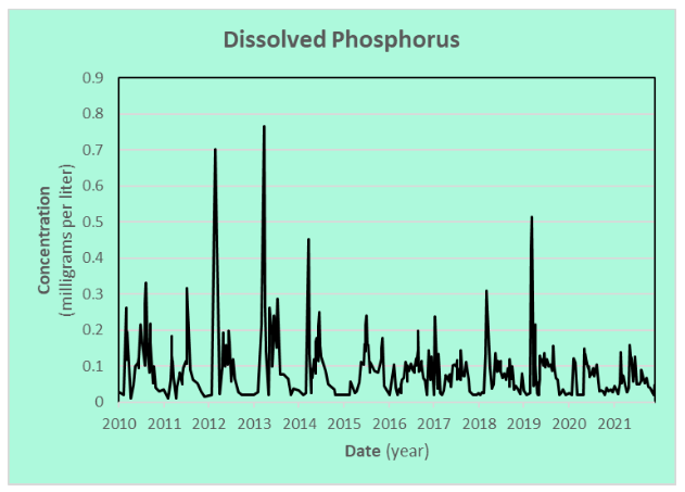
Phosphorus is an essential plant nutrient that is carried by streams. Naturally occurring phosphorus concentrations may be enriched from animal waste and fertilizers, and phosphorus is often introduced with runoff. Phosphorus is often associated with sediment but is more available to plants when dissolved in the water. The adjacent chart shows the phosphorus concentrations in samples from Credit River after the water has been filtered to remove the sediment-associated phosphorus, which generally is considered dissolved phosphorus.
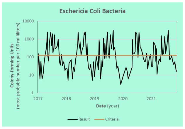
Eschericia coli
Eschericia coli (E.coli) is an organism used to indicate the amount of fecal contamination in lakes and streams. Swimming in or ingesting water with high levels of E. coli could result in illness. The allowable limit is a monthly average of fewer than 126 colony-forming units per 100 milliliters of water between April and October (MPCA 2021). Credit River water often has levels of E. coli that could exceed the allowance for recreational and human health.
References
MCES. 2014. Comprehensive Water Quality Assessment of Select Metropolitan Area Streams. Assessment, St. Paul, MN: Metropolitan Council Environmental Services. https://metrocouncil.org/Wastewater-Water/Services/Water-Quality-Management/Stream-Monitoring-Assessment/Minnesota-River-Tributary-Streams-Assessment.aspx.
MCES. 2014. Credit River Fact Sheet. Fact Sheet, St. Paul, MN: Metropolitan Council Environmental Services. Accessed January 03, 2022. https://metrocouncil.org/Wastewater-Water/Services/Water-Quality-Management/Stream-Monitoring-Assessment/Minnesota-River-Tributary-Streams-Assessment/Mn-River-Trib-Assessment-Reports/Credit-River-Factsheet.aspx.
MNDNR. 2021. Stream Basics. Minnesota DNR. Accessed Nov 3, 2021. https://www.dnr.state.mn.us/fishing/trout_streams/stream_basics.html.
MPCA. 2018. TCMA Chloride TMDL—Applicable Water Quality Standards and Numeric Water Quality Targets. May 18. Accessed Nov 8, 2021. https://stormwater.pca.state.mn.us/index.php/TCMA_Chloride_TMDL_-_Applicable_Water_Quality_Standards_and_Numeric_Water_Quality_Targets
—. 2022. Minnesota’s Impaired Waters List. Minnesota Pollution Control Agency. April. Accessed June 21, 2022. https://www.pca.state.mn.us/water/minnesotas-impaired-waters-list.
This data was last updated January 2022.