Stream ID
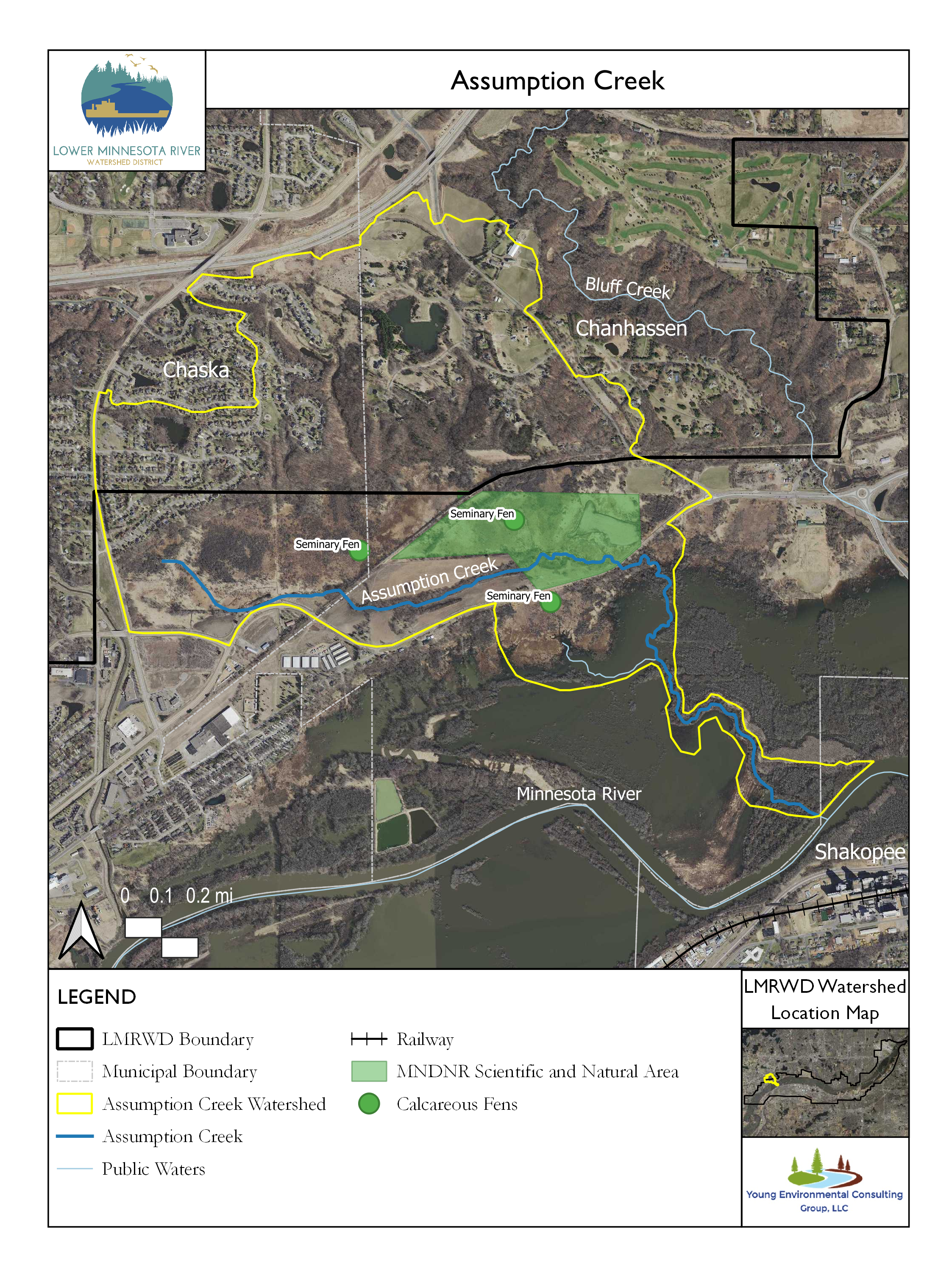
Assumption Creek is a small stream in the southwestern suburbs of Minneapolis. Identified by the Minnesota Department of Natural Resources (MNDNR) as M-055-017, it is a tributary to the Minnesota River. The creek is an MNDNR-designated trout stream, making it an important resource for the Lower Minnesota River Watershed District. The MNDNR reports the stream’s length as 0.93 miles or 1.50 kilometers.
Assumption Creek begins where constantly flowing drainage from the northeast meets a small stream from the northwest along a repurposed railway. After passing beneath the railway, the creek flows east through forested buffers within agricultural fields. The stream then passes through the Seminary Fen Wetland Complex (SFWC), a designated Scientific and Natural Area (SNA) owned and managed by the MNDNR. The SFWC is almost completely dependent on the continuous discharge of cold groundwater. That groundwater is nearly saturated with calcium carbonate and magnesium carbonate, minerals needed to support the unique plant life of the fen. Young (2021) discusses how the positive, upward flow of groundwater supplies water to Seminary Fen. The same upward groundwater flow likely supplies water to the creek when there is no runoff. Berg (2019) affirms that Seminary Fen is a source of water for Assumption Creek. It is not known whether there are plants and animals in Assumption Creek that have a similarly unique requirement for carbonate enrichment. Beyond the SFWC, the creek is bordered by farmland where corn typically is cultivated. The creek flows southeast under Trunk Highway (TH) 61/Flying Cloud Drive onto the floodplain where it meets the Minnesota River. The watershed of the creek also includes bluffs to the west and north. Areas of the watershed are designated for residential and urban land use with the potential for significant impervious surface cover, which might increase runoff to the stream.
Although maps showing Assumption Creek suggest that the entire length could hold trout, that is likely not the case. Above the SFWC, the creek tends to be intermittent and may not have flowing water throughout most of the year. Below where the creek passes beneath TH 61/Flying Cloud Drive, the stream is subject to flooding from the Minnesota River. This creates an environment that is unfavorable for trout.
No trout have been observed in Assumption Creek during recent visits (Berg 2019). Streamflow was monitored at two sites in the river during the summer of 2006 (LMRWD 2006). One site had streamflow only after runoff events. The other site had a baseflow of about 3 cubic feet per second, with higher flow following runoff events. The water surface elevation is being recorded by the Carver Creek Watershed Management Organization, but there is not enough information to use the gathered data to estimate streamflow.
Monitoring Data
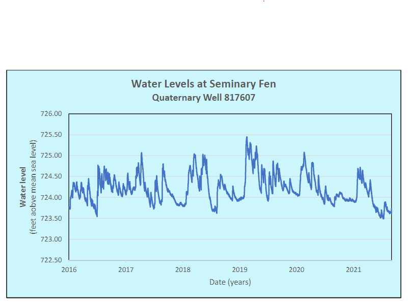
Water Level
Groundwater seems to greatly influence Assumption Creek streamflow. The Fens Gaps Analysis report by Young (2021) provides data from many SFWC wells. Recent water-level data from a selected nearby well is provided below. The water levels for this 79-feet deep well, which is located about 200 feet south of the creek, are consistently higher in elevation than the estimated 720-feet elevation of the creek nearest the well. This shows the upward pressure of groundwater toward the surface, which provides flow to the creek.
Assumption Creek was assessed for the Lower Minnesota Watershed Stream Stressor Identification Report (Henrick 2018). It was assigned Assessment Unit Identifier (AUID) 07020012-582. In preparation for the assessment, the creek was sampled for plant nutrients and suspended particulates on four separate occasions during August 2016 and 2017. Habitats and fisheries were also assessed during several visits by the MNDNR. Results suggest that a trout population previously established in the stream is gone (Henrick 2018). The report concluded that the impaired fish community in Assumption Creek currently does not have a conclusive stressor. Dissolved oxygen, eutrophication (excessive plant and algae growth), altered flow and connectivity, and chloride were inconclusive as stressors at this time. Nitrates, suspended sediment, and habitat were also ruled out as stressors.
References
Berg, Christina et. al. 2019. “Geomorphic and Habitat Assessments of Trout Streams in the Lower Minnesota River Watershed District,” Lower Minnesota River Watershed District. Accessed October 19, 2020. http://lowermnriverwd.org/application/files/4115/7307/3877/LMRWD_Trout_Geo_and_Hab_Asse__Final_Draft_Nov2019.pdf.
Henrick, Chandra and Koschak, Mike. 2018. “Lower Minnesota River Watershed Streams Stressor Identification Report. ” Minnesota Pollution Control Agency.
LMRWD. 2006. Ass_Crk_flow_06.pdf. Accessed October 19, 2021. http://www.lowermnriverwd.org/application/files/4314/9686/8064/Ass_Crk_flow_06.pdf.
Young. 2021. “Fens Sustainability Gaps Analysis - Carver, Dakota, and Scott Counties, Minnesota. ” Lower Minnesota River Watershed District.
This data was last updated June 2022.