photo: Young Environmental
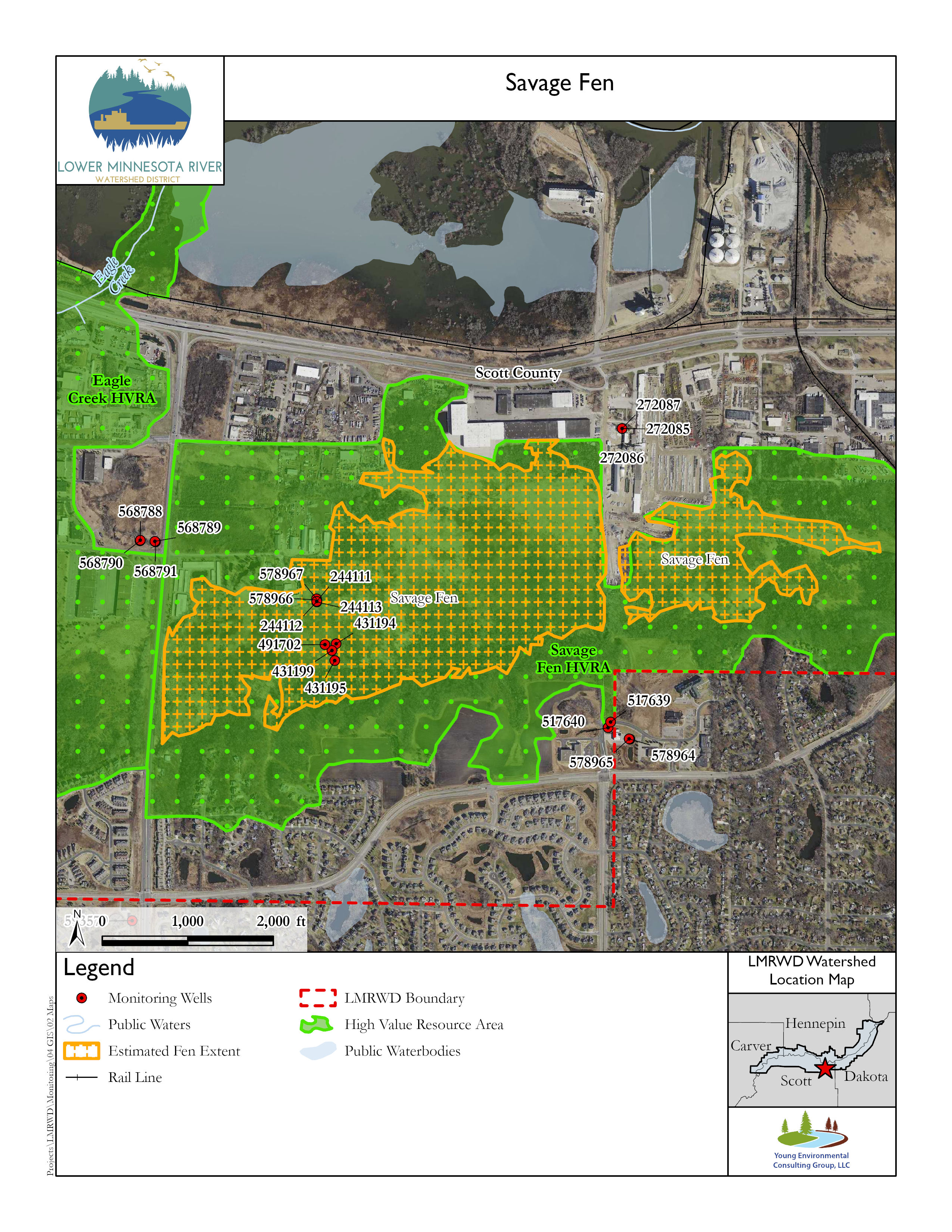
Savage Fen is a cluster of vegetation groupings in Scott County, in the City of Savage. It is roughly bounded by McColl Drive to the south, State Highway 13 on the north and west, and the Credit River to the east. The Savage Fen cluster comprises several distinct areas identified by the unique vegetation characteristic of calcareous fens. Most of the cluster is within the Savage Fen Scientific Natural Area (SNA). The estimated fen extent exceeds the points identified as Savage Fen in the following map, often going well beyond the area defined as the SNA. The fen is adjacent to Eagle Creek, which is a productive, spring-fed trout stream to the west that probably relies on the upwelling of the same groundwater that supplies the fen.
In 2024, the LMRWD Board of Managers was presented with a stewardship plan for Savage Fen. The Savage Fen Stewardship Plan (Stewardship Plan) has been prepared and identifies stewardship and management actions, areas of additional study, and education and outreach opportunities for Savage Fen.
This Stewardship Plan represents the continued commitment to the LMRWD’s goal to protect, enhance, and sustain the valuable resources, like Savage Fen, that lie within its boundaries. The Stewardship Plan’s focus is to outline stewardship and management needs and actions to protect, restore, and sustain Savage Fen. Those stewardship needs and actions are presented early in the plan to highlight their importance. Information and data on the fen and the surrounding area, including data
gathered since the completion of the Gaps Analysis, are presented later in the Stewardship Plan and attachments. The Gaps Analysis also includes additional, detailed background information and data that informed the recommendations of this Stewardship Plan.
Topography and Land Use
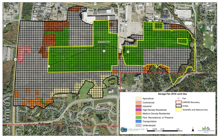
Savage Fen is surrounded by residential, industrial, and commercial land use, with some agricultural areas remaining. The fen cluster is separated from the Minnesota River Valley by State Highway 13 and some light industry to the north. It lies at the base of bluffs that are about 100 feet high to the south. The plateau above the bluffs, which constitutes much of the shallow-groundwater recharge area, is primarily agricultural, residential, and undeveloped.
The adjacent map shows that much of the area surrounding the fen cluster and the SNA is protected as a high-value resource area (HVRA). The goals of establishing HVRAs are to understand, preserve, protect, and restore unique natural resources while evaluating projects that propose to alter them. Much of the land encompassed by the Savage Fen HVRA is undeveloped.
Because of its proximity to urban areas, the Savage Fen cluster has experienced many disturbances, including encroachments, dumping, and off-road vehicle use. Several attempts have been made to complete Dakota Avenue (County State Aid Highway 27) through the fen cluster by going between the major parts of the SNA. So far, authorization to complete the road has been denied because the project could change fen hydrology and connectivity.
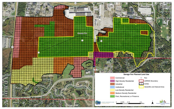
The planned land use map shows that by 2030 much of the HVRA land adjacent to and upgradient of the fen cluster could be converted from agricultural and undeveloped land into residential and multi-optional development. Multi-optional development includes residential, industrial, commercial, and office uses (MetCo, n.d.). The proposed types of development are a high risk to the fen. They may change the hydrology or reduce groundwater recharge because new impervious surfaces typically direct groundwater recharge elsewhere or direct unwanted runoff into the fen. Establishing building foundations and other subsurface work in these areas where the water table is shallow could change the subsurface hydrology both during and after construction.
Private ownership represents 59 percent of the HVRA land surrounding the Savage Fen cluster (Young Environmental, 2021). With the potential for private lands to develop into higher-risk categories, Young Environmental (2021) recommends purchasing private land for conservation at the cost of about $2.2M, based on the 2019 taxable value of the land. Grant funding sources are available for the purchase of conservation lands, including the Legislative-Citizen Commission on Minnesota Resources and the Trust for Public Lands.
Vegetation
Vegetation surveys have been conducted several times at Savage Fen. During the 1980s, vegetation assessments identified the presence of fen indicator species, and from 1987 through 2019, vegetation management of the fen included manual removal and spot spraying of invasive species (Bernardo, 2020). Fen indicator species continued to be identified through the early 2000s to 2019. However, invasive reed grasses and glossy buckthorn continue encroaching on the fen (Eggers, 2020).
Opportunities to restore damaged calcareous fens may be promoted by the results of restoring part of Savage Fen. A portion of the fen was excavated in 1984 and filled with stable material to establish a roadway through the fen. In May 1987, the fen was restored by excavating the artificial fill and replacing it with native peat. With the subsurface hydrology reestablished, the area was planted with native fen vegetation. By 1995, the plant community appeared to have returned to its native population (Young Environmental, 2021).
Geology
The plant community at the surface of the fen is on top of layers of peat between 2–15 feet thick. Beneath that are 3–30 feet of sedimentary glacial deposits. The shallowest bedrock beneath the fen is the Shakopee formation, which is the uppermost layer of the Prairie du Chien group, made primarily of calcium and magnesium carbonates. The Jordan Sandstone under the Prairie du Chien bedrock makes up part of the same aquifer system (Young Environmental, 2021).
Two west-to-east surveys of the earth beneath Savage Fen were conducted in 1997 to determine the depth of geologic features (Skancke, 2019). The results from the first survey suggested that bedrock is about 20–25 feet beneath the fen surface and drops to 40 or more feet below land surface (bls) near the edge of the fen. The results from the second survey suggested that the bedrock surface might be only 15 feet bls but declines steadily from west to east, with some irregularities, to about 40 feet bls.
Hydrogeology
Savage Fen groundwater is recharged on the uplands to the south. The uplands are covered by cultivated and unplanted fields, suburban and rural homes, and numerous small lakes, ponds, and wetlands. Groundwater recharged in the upland areas flows north through the bedrock and overlying glacial till and discharges in the Minnesota River Valley.
Samples of groundwater discharging to the Savage Fen cluster were determined in 1994 to be less than 40 years old (Komor, 1994). Therefore, the groundwater supplying the fen may be susceptible to contamination from polluted recharge water. Understanding what is in the groundwater supply could help explain changes in the fen plant community, which may be sensitive to pollution in the water.
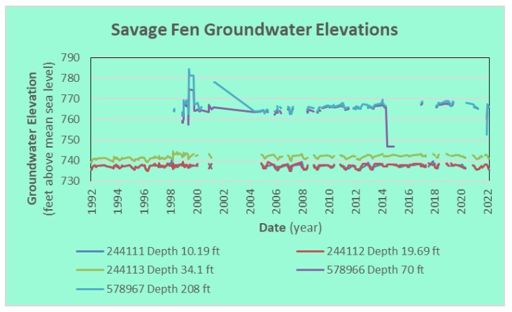
Each groundwater monitoring well has a section open at various levels in the aquifer beneath the fen. This helps scientists determine the water pressure of groundwater at different depths below the fen.
Groundwater elevations in each of the wells are manually measured on a routine schedule, and many of them have been equipped with automatic data recorders at some point in the data-collection program. The data are available from the Cooperative Groundwater Monitoring (GCM) database (MNDNR, 2022). Automated recordings were not included in the plotted data. The manual measurements are considered primary data, while the automated data are adjusted based on the manual measurements.
For various reasons, one or more of the wells were not measured during many site visits, leaving gaps in the data. Missed measurements sometimes were completed days later, and for this presentation, a measurement completed within 10 days of the other wells being measured was included as part of the same measurement. Beyond the 10-day range, they were treated as separate measurements.
The adjacent graph shows groundwater elevations in each of the wells monitored during the past 30 years. It is evident that there have been some erratic measurements of groundwater elevations in the bedrock wells. This occurs from the challenge of accurately measuring groundwater elevations that are about 20 feet higher than the elevation of the measuring point. These wells are typically capped to prevent the water from constantly flowing out from the top of the well. One well is known to have a gauge from which the pressure reading is converted to water elevation. The strong upward pressure from beneath assures the flow of groundwater needed to sustain the fen. With the occasional exception, groundwater levels in the deeper wells are higher than in the shallower wells.
Subtle trends in groundwater elevations appear in the data. The elevation of groundwater in the 34.1-foot deep well appears to have increased by about one to two feet since monitoring began in the early 1990s. Groundwater elevations appear to have increased two to three feet in the deepest wells since about the mid-2000s. These trends suggest an improved supply of groundwater that is needed to sustain the Savage Fen cluster and its unique vegetation.
Geochemistry
A large amount of geochemical data for Savage Fen was collected and summarized by Komor (1994). The groundwater discharging to Savage Fen is rich in calcium and magnesium carbonates, consistent with other nearby fens.
Komor described how the chemistry changes as the water flows from recharge through groundwater aquifers and how it interacts with peat, vegetation, and the atmosphere. It’s suggested that the groundwater follows multiple paths to where it discharges at the fen (Komor, 1994).
Minnesota River Influence
Most of the Savage Fen cluster is above the 500-year floodplain elevation of the Minnesota River (FEMA, 2020). Although the fen hydrology can be affected by flooding, the Minnesota River is not expected to cause that flooding.
Information Gaps and Recommendations
The Savage Fen cluster has been studied for many years by different entities. The following information needs and recommendations are based on work at the Savage Fen cluster but could help our understanding of fen hydrology in general.
-
Savage Fen is expected to experience increased land development, losing most of the open spaces identified in 2016 to planned industrial and commercial developments. Given the potential for effects on the fen, it is suggested that private fen land be purchased for conservation. The preliminary acquisition costs are estimated at $2.2M for Savage Fen (Young Environmental, 2021). Grant funding sources to secure this area for the future are available for the purchase of conservation lands.
-
The vegetation surveys conducted at the Savage Fen cluster demonstrate the continued encroachment of invasive species into the calcareous fen, particularly reed grass and buckthorn, since the mid-1980s. Future management should consider opportunities to control invasive plants that have the potential to overwhelm the calcareous fen ecosystem.
-
Although the existing wells at Savage Fen are clustered to the west, these wells provide the information needed to evaluate the health of the fen and may provide information about the groundwater connection between the fen and Eagle Creek. The MNDNR recommends reviewing the fen monitoring network to determine whether new wells are necessary, particularly if Dakota Avenue is extended through the fen.
-
Groundwater discharging to the fen is vulnerable to contamination because it is relatively recently recharged, shallow water. Further studies of the effects this may have on Savage Fen are needed to determine if this is a potential risk to fen health.
Much of the information provided in this presentation is contained in the report Fens Sustainability Gaps Analysis for Carver, Dakota, and Scott Counties, Minnesota (Young Environmental, 2021).
References
Bernardo, H. (2020, January 6). SNA_ManagementRecords_Jan2020. Saint Paul, Minnesota.
Eggers, S. (2020, April 20). Savage Fen SNA Releves. Email. U.S. Army Corps of Engineers.
FEMA. (2020). FEMA Flood Map Service Center: Welcome! Retrieved April 6, 2020, from https://msc.fema.gov/portal/home
Komor, S. (1994). Geochemistry and hydrology of a calcareous fen within the Savage Fen wetlands cluster, Minnesota, USA, Geochimica et Cosmochimica Acta, Volume 58, Issue 16, 3353–3367.
MetCo. (n.d.). Regional Planned Land Use Categories. Retrieved March 16, 2020, from https://metrocouncil.org/Data-and-Maps/Data/Metadata/Land-Use-Definitions.aspx
MNDNR. (2022, March 7). Cooperative Groundwater Monitoring (CGM). Retrieved from Cooperative Groundwater Monitoring (CGM): https://www.dnr.state.mn.us/waters/cgm/index.html
NOAA. (2018, July 12). North American Vertical Datum of 1988 (NAVD 88). Retrieved from National Oceanic and Atmospheric Administration National Geodetic Survey: https://geodesy.noaa.gov/datums/vertical/north-american-vertical-datum-1988.shtml#:~:text=North%20American%20Vertical%20Datum%20of%201988%20(NAVD%2088)%20consists%20of,origin%20point%20on%20the%20continent
Skancke, J. (2019, December 30). Seismic Survey of Savage Fen.
Young Environmental. (2021). Fens Sustainability Gaps Analysis - Carver, Dakota, and Scott Counties, Minnesota. Minneapolis, Minnesota: Lower Minnesota River Watershed District.
This data was last updated July 2022.