photo: Barr Engineering
Nicols Meadow Fen is a cluster of vegetation groupings in Dakota County, partially in Fort Snelling State Park and the City of Eagan, northeast of Cedar Avenue (Trunk Highway 77) and northwest of Trunk Highway 13. Nicols Meadow Fen and Black Dog Lake North Fen may have been part of the same fen before Cedar Avenue divided them. The fen cluster consists of three vegetation groups, designated as A, B, and C, adjacent to a Union Pacific (UP) railway (formerly the Chicago and Northwestern Rail). Nicols Road runs through the fen, which may be the origin of the fen’s name. Nicols Meadow Fen is associated with two trout streams, Kennaley’s and Harnack (aka Unnamed 1) Creeks, that no longer support a trout population (Young Environmental, 2022).
Nicols Meadow Fen and the surrounding area have been disturbed by railway and roadway construction, the construction of a railroad flag station, the establishment of trout ponds on Kennaley’s Creek, municipal stormwater and wastewater-treatment construction projects, and agricultural activities over the years. Flooding from the Minnesota River and beaver activity on the associated creeks may affect the fen in unknown ways. Much of the area surrounding the fen receives special protection as one of the high-value resource areas (HVRA) managed by the Lower Minnesota River Watershed District (LMRWD).

Topography and Land Use
Nicols Meadow Fen lies in the Minnesota River Valley on land that slopes upward to the southeast. Much of the precipitation that falls on upland areas to the southeast of the fen probably recharges the aquifer that provides the upwelling groundwater essential to the fen and surrounding wetlands. This area is a mixture of residential land use interspersed with transportation routes and industrial, retail, and commercial areas. These land uses often include large impervious areas which increases runoff while reducing infiltration and groundwater recharge. A few lakes and ponds might contribute to groundwater recharge, and storm sewers likely move runoff away before it can infiltrate.
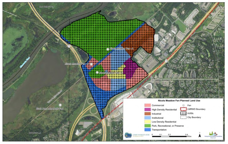
The adjacent map shows the 2016 land use within the HVRA as presented by Young Environmental (2021). The northwest part of the HVRA is designated as park and open space, and the southeast part is a mix of industrial and other land uses with a large amount of undeveloped land. Much of the undeveloped land is near the fen cluster. Because of the shallow water table, development likely would require dewatering, which would seriously damage nearby fens. Post-development land use may increase runoff and threaten nearby natural resources.
Planned land use within the HVRA in 2030 shows that undeveloped land will be converted primarily into commercial and institutional uses. The projected land use does not recognize group B of Nicols Meadow Fen, which changes that parcel from undeveloped into commercial and institutional properties and poses higher risks to the resource (Young Environmental, 2021).
The map showing property ownership within the HVRA surrounding the fen cluster shows that much of the land nearest the fen cluster is in public ownership. This might allow influence over the planned development, encouraging public officials to protect the resource rather than favor higher-risk commercial and institutional development. Young Environmental (2021) suggests that because of the potential to convert low-risk land uses to uses carrying higher risk, some private lands might be purchased to ensure that future land use conserves the resource.


Vegetation
Several vegetation surveys have been conducted at Nicols Meadow Fen since the 1980s. During site visits in 1980 and 1982, several calcareous fen indicator species were present but were not the dominant plant community; many other wetland plants were identified. In 1994, a formal vegetation survey found an abundance of calcareous fen indicator species, suggesting a healthy fen community even though less-desirable plants were found, such as reed grasses. Site visits in 2000 and 2001 described the invasive reed grass, and in 2003, none of the plants found were fen indicator species. By 2017, the Nicols Meadow Fen was described as still having rare fen indicator plants but being affected by stormwater, pollution, and invasive species and requiring protection.
Geology
The geology at Nicols Meadow Fen generally consists of peat over alluvial sand deposits. The deposits are primarily part of the St. Croix glacial moraine. The bedrock surface is about 100 to 150 feet below ground surface and is primarily the Prairie du Chien formation. A buried bedrock valley to the northeast exposes Jordan sandstone and is deep enough to expose the underlying St. Lawrence and Franconia dolomitic shale and siltstone (Balaban & Hobbs, 1990).
Because the bedrock near the fen is deep, it should not affect the fen. Almendinger and Leete (1998a and b) noted that the alluvial aquifer has sufficient carbonate minerals to enrich recharge waters with calcium and magnesium carbonates before discharging to the fen without having to contact the carbonate bedrock.
Hydrogeology
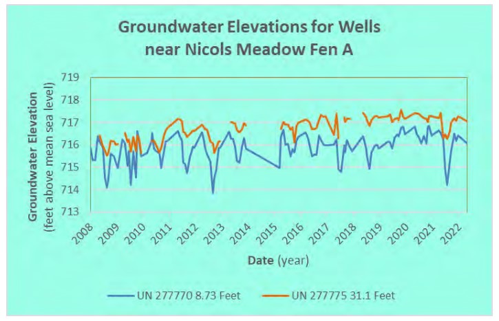
The groundwater near Nicols Meadow Fen flows northwest toward the Minnesota River. Groundwater monitoring wells in or near the fen cluster are open at different levels in the aquifer beneath the fens to help scientists determine the water pressure of groundwater at various depths below the fen groups.
The groundwater elevation data and well information were retrieved from the Cooperative Groundwater Monitoring (CGM) online database (MNDNR, 2022).
The adjacent graphs show the groundwater elevations at selected wells near Nicols Meadow Fen clusters A and B using data retrieved from the CGM database. Additional wells are monitored by various organizations, and a review of data from those wells showed that they provide comparable information (Young Environmental, 2021).
Like healthy fens nearby, water elevations in the deeper wells are higher than in the shallower wells. This shows that replenishing groundwater is pushing toward the surface (Young Environmental, 2022). Gaps in the data lines for some of the wells usually result from unsuccessful groundwater-level measurements because of water frozen in the above-ground part of the well during late winter.
Historically, the groundwater hydrology in and near Nicols Meadow Fen has been subjected to various hardships that could have adversely affected the sustained upwelling of groundwater needed by the fen. The nearby Seneca Wastewater Treatment Plant, constructed in 1972 and expanded in 1992, actively dewaters 380 million gallons of water each year from aquifers adjacent to the fen (Young Environmental, 2022). Dewatering for the construction of the Seneca Wastewater Treatment Plant expansion in 1992 in the vicinity of Nicols Meadow Fen may have lowered the water table in the peat (WSB & Associates, Inc., 2008). In addition, the City of Eagan’s municipal well fields withdraw groundwater from aquifers located within 3 miles of Nicol Meadows Fen (Young Environmental, 2021).
The City of Eagan constructed a stormwater outfall into Nicols Meadow Fen in 1959. A major storm in July 2000 caused severe erosion at the outfall. A 2004 technical evaluation described that decades of stormwater outflow had eroded an open cavity approximately 20 feet deep and 30 feet in diameter. The evaluation also noted groundwater seepage from the adjacent fen area. The City of Eagan subsequently relocated that storm sewer outfall further to the north and restored the eroded area and associated damage (WSB & Associates, Inc., 2008).

Geochemistry
Almendinger and Leete (1998a and b) noted that groundwater samples from Nicols Meadow Fen had substantially altered carbonate content that apparently resulted from chemical reactions associated with dewatering and peat decomposition and was not representative of natural fens. They noted that selected data from Nicols Meadow Fen were used in their study to contrast with those from other studied fens because the Nicols Meadow Fen had been so degraded at the time of their sampling (Almendinger & Leete, 1998a and b).
No additional geochemistry data for Nicols Meadow Fen were found.
Minnesota River Influence
Nicols Meadow Fen is not likely to be affected by Minnesota River flooding. The 100-year flood water surface elevation near Nicols Meadow Fen is approximately 714.6 feet MSL, and measured groundwater elevations generally are much higher than that.
Information Gaps and Needs
Nicols Meadow Fen and its associated resources have been adversely affected by various disturbances over many years and continue to show the scars of those disturbances. Before the value of calcareous fens was recognized and regulatory protections were established, the fen was home to residents of the abandoned community of Nicols, MN (Dakota County Historical Society, 1989). Parts of the fen have been altered, drained, and filled for the construction and upgrades of the UP Railway, Trunk Highway 77, and other facilities. Groundwater pumping and dewatering during construction near Nicols Meadow Fen caused peat dewatering and subsidence. Below are some information gaps and needs that could inform and enhance management of the fen:
• Given the potential for the development of private lands within the Nicols Meadow Fen, portions of these parcels should be purchased for conservation. Based on this preliminary assessment and the 2019 full market value, the cost to purchase and conserve this area is estimated at $296,000 (Young Environmental, 2021).
• Completing timely vegetation relevés would help document the status of the floral communities. Vegetation surveys at Nicols Meadow Fen show a trend starting in the 1980s of a gradual decline in fen-indicator species and an increase in less desirable and invasive plants, such as reed grass. Several vegetation surveys identified invasive species as problematic in Nicols Meadow Fen. Once established, invasive species can drastically alter the fen community by displacing native fen plants.
• Municipal and commercial groundwater withdrawals by the City of Eagan and the Seneca Wastewater Treatment Plant should be evaluated to determine if these permitted appropriations affect the Nicols Meadow Fen water supply.
• If groundwater withdrawals are determined to negatively affect Nicols Meadow Fen and associated creeks, options for reducing the impact of those withdrawals should be explored to minimize adverse effects on the resources.
• Coordination of monitoring and data-collection activities by the MNDNR, the Dakota County Soil and Water Conservation District, and the Metropolitan Council Environmental Services near Nicols Meadow Fen could improve efficiency and reduce redundancy.
Nicols Meadow Fen has the potential to be one of the few remaining thriving calcareous fens left along the Minnesota River. Thoughtful management and protection of the fen and associated resources could guarantee its preservation.
Much of the information provided in this presentation is contained in the report Fens Sustainability Gaps Analysis for Carver, Dakota, and Scott Counties, Minnesota (Young Environmental, 2021).
References
Almendinger, J. E., & Leete, J. H. (1998a). Regional and local hydrogeology of calcareous fens in the Minnesota river basin, USA. Wetlands.
Almendinger, J. E., & Leete, J. H. (1998b). Peat Characteristics and Groundwater Geochemistry of Calcareous Fens in the Minnesota River Basin, U.S.A. Biogeochemistry, 17–41.
Balaban, N., & Hobbs, H. (1990). C-06 Geologic atlas of Dakota County, Minnesota. Retrieved May 21, 2019, from Minnesota Geological Survey.University of Minnesota Digital Conservancy: http://hdl.handle.net/11299/58494
Dakota County Historical Society. (1989, Fall). Nicols: The Life and Death of a Most Unusual Town. Over the Years, 29.
MCBS. (2017). Minnesota County Biological Survey: Dakota County, MN. St. Paul, MN: Minnesota County Biological Survey.
MNDNR. (2022, Mar 7). Cooperative Groundwater Monitoring (CGM). Retrieved from Cooperative Groundwater Monitoring (CGM): https://www.dnr.state.mn.us/waters/cgm/index.html
WSB & Associates, Inc. (2008). Environmental Monitoring of Nicols Fen, Conservation Partnership Grant #CP05-014. Retrieved May 22, 2019, from https://www.co.dakota.mn.us/parks/About/TrailPlanning/Documents/MinnesotaRiverGreenwayNicolsFenReport.pdf
Young Environmental. (2021). Fens Sustainability Gaps Analysis - Carver, Dakota, and Scott Counties, Minnesota. Minneapolis, Minnesota: Lower Minnesota River Watershed District.
Young Environmental. (2022). Seminary Fen Management Plan. Chaska, MN: Lower Minnesota River Watershed District.
Young Environmental. (2022, May 14). Trout Streams Gaps Analysis and Management Plan. Chaska, MN: Lower Minnesota River Watershed District. Retrieved Jun 20, 2022, from http://www.lowermnriverwd.org/download_file/view/2618/227
This data was last updated July 2022.