photo: Barr Engineering
Gun Club Lake Fen was a large fen complex situated near the eastern edge of the floodplain in the Minnesota River Valley until it was divided in 1985 by the construction of Interstate Highway 494 (I-494) (Dakota County SWCD, 2018). Gun Club Lake North Fen, also known as Quarry Island Fen, is on the north side of I-494, whereas Gun Club Lake South Fen, also known as Fort Snelling Fen, is on the south side of I-494. Both parts of the fen are located along the Union Pacific (UP) railway within Fort Snelling State Park and the City of Eagan in Dakota County. The area surrounding the fen receives special protection as one of the high-value resource areas managed by the Lower Minnesota River Watershed District (LMRWD). The northern part has received some study and data collection, while the southern portion has been studied more extensively and has a greater number of monitoring wells. To the extent possible, this summary discusses the fen as a single entity, although most of the information is focused on the southern part of the fen. Much of the information in this presentation is contained in the report titled Fens Sustainability Gaps Analysis for Carver, Dakota, and Scott Counties, Minnesota (Young Environmental, 2021).
Most of the area surrounding Gun Club Lake Fen is favorable fen habitat. It is labeled in the adjacent illustration as “Estimated Fen Extent.” If conditions are suitable, the fen and its distinctive plant life might expand to this greater area, but it is not known whether the fen was ever that large.

Topography and Land Use
The land near Gun Club Lake Fen slopes upward to the east from the Minnesota River Valley floor. Current land use upgradient from the fen includes light industrial, residential, and some open space. Water falling on uplands to the east of the fen that does not run off is likely to drain into the ground to replenish the groundwater that is believed to supply the upwelling water that sustains the fen. Land use planned for this area is not much different than current land use. Because the fen is surrounded by park land, any encroachment on the fen would originate from the UP railway that passes to the east of the fen or I-494, which passes through the fen.
Vegetation
The only known vegetation assessment of the northern part of Gun Club Lake Fen was conducted by H. Dunevitz on July 20, 1994. It documented the presence of at least two fen-indicator species (Young Environmental, 2021). Vegetation in the southern part of the fen was assessed in 1982, 1993, 1994, and 2004. Findings from those assessments are summarized from Young Environmental (2021):
• A vegetation assessment in September 1982 indicated that various calcareous fen indicator species were present, suggesting a healthy ecosystem.
• A calcareous fen data sheet dated October 1999 summarized the results of vegetation surveys conducted during 1993 and 1994. It described multiple areas of calcareous groundwater discharge, dominated by several calcareous-fen indicator species, indicative of a strong and healthy calcareous fen ecosystem.
• A formal vegetation survey, called a relevé, was completed in August 2004. It reported a small, healthy, and highly diverse population of fen-indicator plants surrounded by disturbed areas of invasive plants threatening the area.
This summary suggests the south part of Gun Club Lake Fen is healthy, but the status of the northern part is unknown. Limited information suggests that the northern part of the fen may be degraded.
Geology
The geology beneath Gun Club Lake Fen is entirely water-saturated and consists of a layer of peat over sandy alluvial deposits. Peat forms the layer that supports the fen vegetation and ranges between 20 to 25 feet in thickness. The peat is on top of sand and gravel that reaches nearly 50 feet below the surface in the southern part. Thin layers of clay and silt in the sand and gravel layer could slow the vertical movement of water. Sand below the layered sand and gravel reaches at least 85 feet below the surface. Bedrock is present at approximately 50 feet below the surface to the north and about 100 to 150 feet below the surface at the southern part of the fen (Balaban & Hobbs, 1990); however, monitoring wells have not been drilled deep enough to verify the bedrock depth.
Hydrology and Hydrogeology
The fen is supplied with upwelling groundwater that is most likely recharged from nearby uplands to the east (Young Environmental, 2021). Impervious surfaces in the upland urban areas may redirect rainfall away rather than allowing it to infiltrate into the ground to replenish the groundwater supply. There are a few ponds and other areas that might capture runoff and improve fen groundwater supply.
Uncontrolled runoff can be detrimental to the fen. Records from an unidentified observer on March 12, 2003, described “a ditch excavated across the fen with a spring found.” The observation also described “a pronounced ice dome that is not from the spring; it is from the stormwater problem,” indicating disturbance of the fen based on information received from the MNDNR. Undated photographs show severe erosion through the peat layer because of excess stormwater discharge through the fen (Young Environmental, 2021). Accidentally or intentionally creating a ditch through the fen will drain it, drying out the fen vegetation and its peat layer, which will change the hydrology and the ecosystem.
Monitoring wells are installed in both the north and south parts of the fen. Two groundwater monitoring wells are north of I-494, and thirteen groundwater monitoring wells are south of I-494. They range in depth from 5 to 80 feet (Young Environmental, 2021). The LMRWD funds monitoring activities by the Dakota County Soil and Water Conservation District (SWCD), which routinely measures water levels in selected wells, compiles the data, and supplies them to the LMRWD. The MNDNR also measures water levels in selected wells and uploads their data to the Cooperative
Groundwater Monitoring (CGM) network (MNDNR, 2022). Groundwater levels are normalized to mean sea level (MSL) elevation (NOAA, 2018), allowing comparison of groundwater elevations among wells.
Groundwater elevations from aligned wells south of I-494 measured on November 7, 2013, were used to produce the adjacent cross-section graphic, which is an illustration from Burns and McDonnell (2015). Groundwater elevation contours show that deep groundwater is consistently pushing toward the surface. Many of the wells, particularly the deeper ones, have groundwater elevations so high that water flows out of their tops. It is challenging to measure the groundwater elevation in an overflowing well. If there is water in the above-ground section of a well during the winter months, the water in the standing pipe can freeze, preventing measurements of winter water levels.
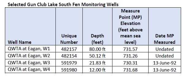
Groundwater elevations and well information were downloaded from the CGM website for a few selected wells that are actively monitored. Specifically, a cluster of four wells south of I-494 that are exposed to the underlying aquifer at specific depths were chosen for this presentation.
The adjacent graph shows the groundwater elevations at each of the four wells. Gaps in the data lines are usually the result of unsuccessful groundwater-level measurements because of water frozen in the above-ground part of the well during late winter. The groundwater elevations for the deeper wells are higher than for the shallower wells, confirming that pressure from beneath is causing the upward flow of groundwater. A trend of increasing groundwater elevations in the deeper wells is also noticeable, with levels rising from less than 728 feet above MSL before 2010 to about 729 feet MSL in recent years. This suggests improvement in the sustained flow of groundwater to supply water needed by the fen. Groundwater elevations in the shallow well remained relatively constant—near or less than 727 feet MSL, which may be the level of the fen surface.


Geochemistry
Almendinger and Leete (1998a) performed a comprehensive sampling of the geochemistry of Gun Club Lake Fen south of I-494 in 1998. The fen groundwater chemistry had high concentrations of calcium and magnesium cations typical of fens. They stated that the water chemistry changes because water lacking oxygen from a confined aquifer is exposed to atmospheric pressures and becomes oxygenated (Almendinger & Leete, 1998a, 1998b).
No subsequent geochemical data for Gun Club Lake Fen have been found.
Minnesota River Influence
Review of the December 2, 2012, Federal Emergency Management Agency Flood Insurance Rate Maps for Dakota County indicates that portions of Gun Club Lake Fen may be flooded during a 100-year flood on the Minnesota River (Young Environmental, 2021). It can only be imagined how flooding would affect the fen hydrology and vegetation. Gun Club Lake Fen has probably adapted to variations in the Minnesota River water levels because age dating of peat deposits in nearby fens suggests that they have been around for 10,000 years (Almendinger & Leete, 1998a).
References
Almendinger, J. E., & Leete, J. H. (1998a). Peat characteristics and groundwater geochemistry of calcareous fens in the Minnesota River Basin, USA. Biogeochemistry, 17–41.
Almendinger, J. E., & Leete, J. H. (1998b). Regional and local hydrogeology of calcareous fens in the Minnesota River Basin, USA. Wetlands.
Balaban, N., & Hobbs, H. (1990). C-06 geologic atlas of Dakota County, Minnesota. University of Minnesota Digital Conservancy. http://hdl.handle.net/11299/58494
Burns & McDonnell. (2015, September 16). Groundwater and fen evaluation summary report September 16, 2015 [PowerPoint slides].
Dakota County SWCD. (2018). 2018 fen well monitoring report. https://lowermnriverwd.org/application/files/5015/5216/6967/2017_Fen_Well_Monitoring_Report_Dakota.pdf
MNDNR. (2022, March 7). Cooperative groundwater monitoring (CGM). Cooperative Groundwater Monitoring (CGM). https://www.dnr.state.mn.us/waters/cgm/index.html
NOAA. (2018, July 12). North American vertical datum of 1988 (NAVD 88). National Oceanic and Atmospheric Administration National Geodetic Survey. https://geodesy.noaa.gov/datums/vertical/north-american-vertical-datum-1988.shtml#:~:text=North%20American%20Vertical%20Datum%20of%201988%20(NAVD%2088)%20consists%20of,origin%20point%20on%20the%20continent.
Young Environmental. (2021). Fens sustainability gaps analysis—Carver, Dakota, and Scott Counties, Minnesota. Lower Minnesota River Watershed District.
This data was last updated July 2022.