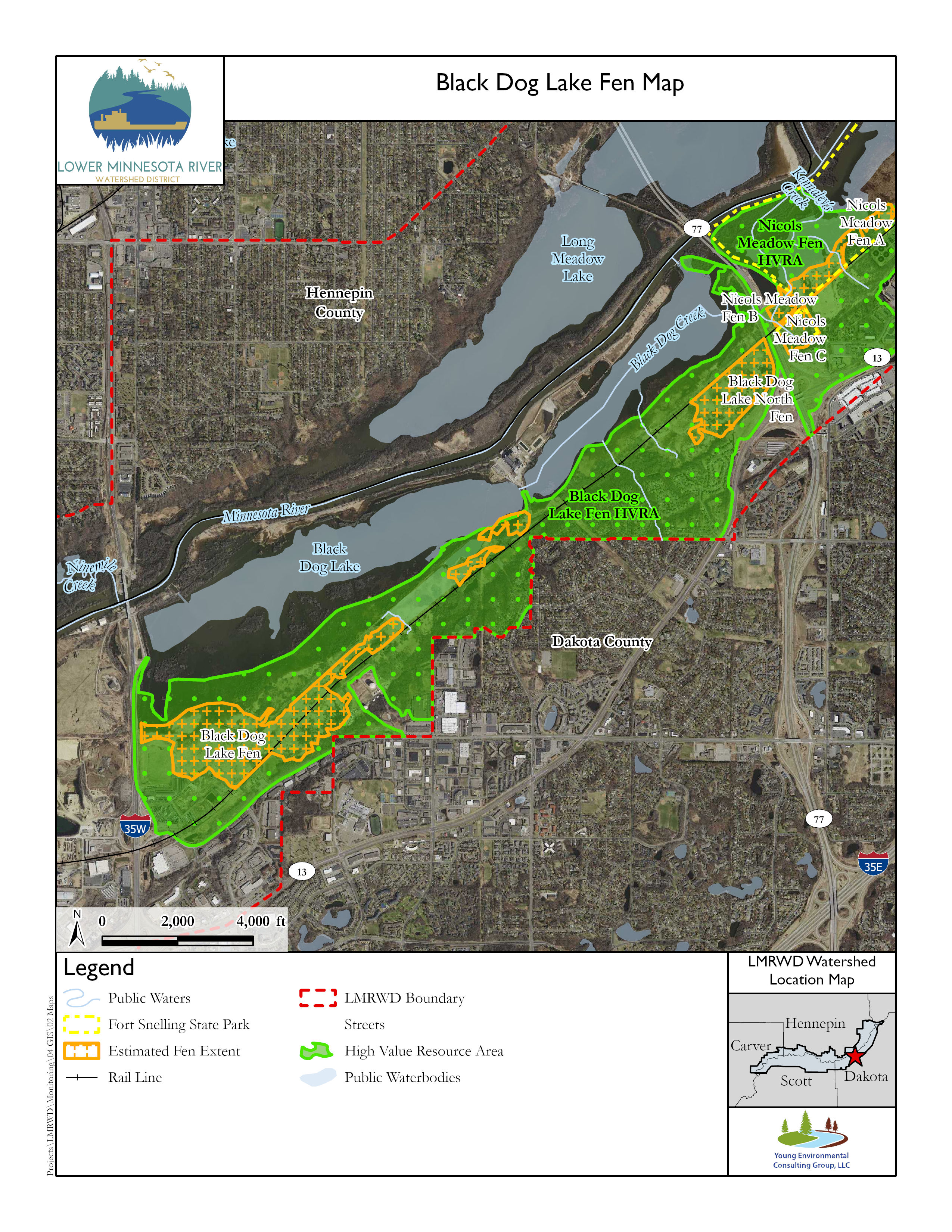
Black Dog Lake Fen is located near the edge of the floodplain in the Minnesota River valley in the City of Burnsville in Dakota County. It is along the Union Pacific railway east of Interstate 35W. Another fen, named Black Dog Lake North Fen, has been identified about 2.5 miles to the northeast of Black Dog Lake Fen. Because of its proximity to Nicols Meadow Fen, which is on the opposite side of Trunk Highway 77 (i.e., Cedar Avenue), the North Fen may have been part of Nicols Meadow Fen before road construction divided them.
Black Dog Lake Fen has been identified as three to four vegetation groups: a, b, c, and possibly d, which may be an extension of group c. As seen in the adjacent map, areas surrounding both the main and north fen suggest the potential for a larger fen.
Black Dog Lake Fen has been degraded by various outside pressures, including land development and the construction associated with Interstate 35W. Nearby permitted water withdrawals continue to affect the fen complex (Young Environmental, 2021).
Groundwater levels have not been monitored in or near Black Dog Lake Fen, so there is no record of how nearby activities may have affected groundwater levels beneath the fen. The time and expense of establishing a groundwater monitoring network may not be justified because of unrecoverable damage to the fen.
Groundwater supplies to Black Dog Lake Fen could be enhanced or impaired by future development. Closing a nearby quarry and converting it into a water supply reservoir could allow groundwater levels to recover and restore flow to the fen complex. Mitigation of a nearby leaking closed landfill (USEPA, n.d.) or expansion of a nearby quarry could have the opposite effect because they may require dewatering, which would lower groundwater levels.
Erosion by runoff appears to have cut into the material supporting fen groups a and b. The eroded ditch drains water from beneath the fen, drying out the plant community and compacting the peaty substrate.
It is unknown whether the fen vegetation can recover by restoring the groundwater supply. Pockets of native plants may exist, but it is not clear that the fen community is intact. The calcareous fen at Black Dog Lake may be gone because of the changed hydrology.
A 2017 survey of Black Dog Lake North Fen described it as a disturbed former fen that is now a wet meadow with emergent marsh in the wettest areas and considerable invasive reeds with some ditching through the fen. The survey only identified one small fen-like area with unspecified rare plants (MCBS, 2017).
Vegetation assessments of Black Dog Lake Fen in 2018 and 2019 identified no fen-indicator species at any of the sites. They observed considerable ditching and invasive vegetation (Young Environmental, 2021).
Much of the information provided in this presentation is contained in the report Fens Sustainability Gaps Analysis for Carver, Dakota, and Scott Counties, Minnesota (Young Environmental, 2021).
References
MCBS. (2017). Minnesota County Biological Survey: Dakota County, MN. St. Paul, Minnesota: Minnesota County Biological Survey.
USEPA. (n.d.). Freeway Sanitary Landfill Superfund Site Info. Retrieved August 8, 2019, from https://cumulis.epa.gov/supercpad/cursites/csitinfo.cfm?id=0503760.
Young Environmental. (2021). Fens Sustainability Gaps Analysis—Carver, Dakota, and Scott Counties, Minnesota. Minneapolis, Minnesota: Lower Minnesota River Watershed District.
This data was last updated July 2022.